
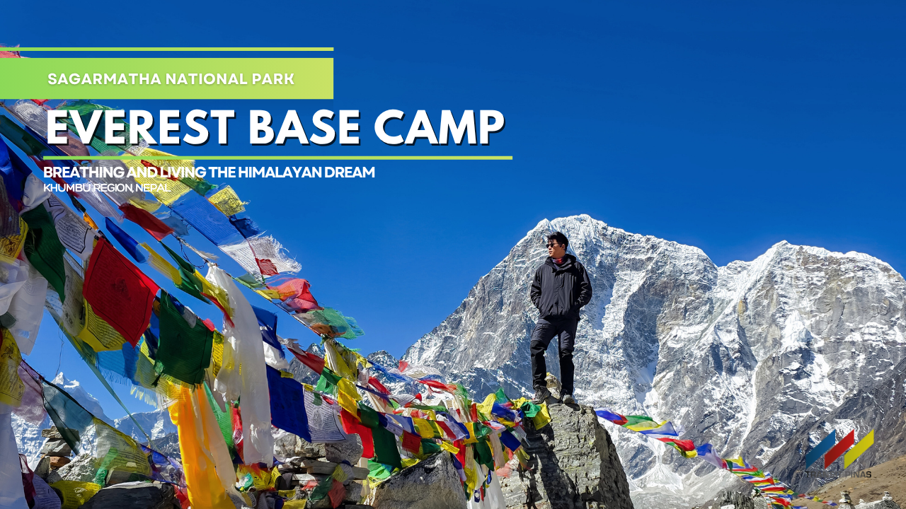
Part I: Everest Base Camp (5,364m) – Breathing and Living the Himalayan Dream
PART I – SAGARMATHA NATIONAL PARK, NEPAL: Fourteen days in the Himalayas. Every grueling step going to the Everest Base Camp tested not just our lungs, but the very core of our mountaineering soul. This wasn’t just a trek; it was an unwavering climb towards a lifelong dream.
![]()
Read more: Part II: Everest Base Camp (5,364m) – Breathing and Living the Himalayan Dream
Everest Unpacked: Our EBC Journey – Part I
Whispers of the Khumbu: A Trek to the Foot of the World
As we began our descent from China to Kathmandu in Nepal, I looked to my right, and there it was: the tip of Mount Everest, just visible above the frozen ridge, its summit exhaling those familiar plumes of powdered snow. From this perspective, she appears almost benign, a mere mountain among many.
![]()
Over the last decade, since I started climbing mountains, even standing at the foot of the world’s highest point has been one of my greatest aspirations. And today, that dream becomes a reality.
![]()
Beyond the maps and guidebooks lies the true spirit of the Himalayas. Join me on an unforgettable expedition as I recount each day of our Everest Base Camp Trek through the whispers of the Khumbu, ascending to the foot of the world—a hallowed ground where legends once stood.
Kathmandu, Nepal: Sensory Overload at its Finest
Our plane touched down at Tribhuvan Airport in Kathmandu, and immediately, the city hit our senses.
![]()

Stepping into the humid air, the first stop was Thamel, a maze of narrow streets. We needed supplies, and this was the place.
“It was chaotic, loud, and utterly captivating.”
Kathmandu is a living, breathing jumble. Everywhere you look, there are red brick buildings, old and new, some crumbling, some vibrant. The air hummed with constant noise: motorbikes zipping by, street vendors calling out, music drifting from shops. And the smells – a mix of exhaust fumes, spices, and the ever-present, calming scent of incense. It was chaotic, loud, and utterly captivating.
![]()
What truly struck me, though, was the Nepali culture alive in every corner. People moved with an easy rhythm, prayer flags fluttered overhead, and temples seemed to appear out of nowhere.
![]()
![]()
![]()
Amidst this beautiful disorder, Thamel also served as a one-stop shop for climbers. Every other store was packed floor to ceiling with mountaineering gear. It was a glorious mess, a promise of the adventure to come.
![]()
![]()

Day 1: From Kathmandu to Kharikhola – The Road to the Himalayas
The journey began in Kathmandu at around 03:30 am the following day. We swapped the city bustle for a cramped 4×4 jeep ride, setting our sights on Kharikhola via Salleri. It was a long haul, driving through mountain passes that easily topped the highest peaks back home in the Philippines.
![]()
After what felt like an endless 16-hour ride on incredibly rough roads, we finally pulled into Khaling Hotel and Lodge in Kharikhola, the elevation is already at 2364 meters.
![]()
The weariness of the drive vanished as we caught our first glimpse of snow-blanketed peaks in the distance. That sight alone was enough to get us excited for what lay ahead.
![]()
![]()
![]()
Day 1: The Trail Begins – Paiya to Chaurikharka
Starting Elevation: 2,660m
Ending Elevation: 2,650m
Total Distance: 10.5km
![]()
Our journey on foot began in Paiya (2660m), the true start of our trek, about 10 kilometers away from Lukla. We skipped the flight, we didn’t hire any porters or guides, and we chose the tougher route going to the jump-off point.
![]()
This was it – the moment I’d been waiting for, the start of a trek of a lifetime. What I’d only seen in videos and photos for so long was now real; I was doing it. The excitement was immense.
![]()
We soon passed through the village of Surke (2312m), at the 6.8-kilometer mark. This is where the jeep tracks ended, marking our full immersion into the walking trails.
![]()

After a satisfying breakfast of Nepali pancakes and hot chai tea, we continued along winding paths that rose and fell. Eventually, we reached the peaceful village of Chaurikharka (2650m), where we would spend the night.
![]()
![]()
![]()
![]()
Our host, Auntie Xiexie, was cheerful and humorous during our stay. She prepared a hot stew for dinner, made with local vegetables and buffalo meat for our Dal Bhat. To top it off, she even gave us free shots of rice wine. It was a warm welcome to the Himalayas.
![]()
![]()
![]()
Day 2: A Gentle Start to the Khumbu – Chaurikharka to Monjo
Starting Elevation: 2,650m
Ending Elevation: 2,870m
Total Distance: 14km (total of 24.5km)
![]()

Day two of our trek began in Chaurikharka (2650m). We began our descent, heading towards Phakding (2,610 m), approximately 18 kilometers into our journey. The path was relatively easy, allowing us to settle into the rhythm of the mountains.![]()
![]()
![]()
We had a brief stop in Phakding for lunch. Right after, we continued to Monjo (2870m), another 6.5 kilometers ahead, marking our 24.5-kilometer point for the day. Monjo is an important stop for all trekkers. Here, just a short distance from our lodge, stood the entrance to Sagarmatha National Park.
![]()
We knew from here on, every step would take us deeper into the heart of Everest’s domain.

This gate signals the official start of the higher elevations and the more challenging, but incredibly rewarding, parts of the trek ahead. We knew from here on, every step would take us deeper into the heart of Everest’s domain.

Day 3: Into the Sherpa Capital
Starting Elevation: 2,870m
Ending Elevation: 3,430m
Total Distance: 8.5km (total of 32km)
![]()
![]()
Leaving Monjo (2,870m), our first stop was the entrance to Sagarmatha National Park in Jorsalle. We needed to secure our trekking permits and get our official trekker IDs there. It’s a key checkpoint before going further into the Everest region.
![]()
![]()
![]()
After sorting out the paperwork, we started hiking up a steep mountain trail. The path was busy; we were constantly sharing it with other trekkers and long lines of donkeys carrying supplies.
![]()
They’re a common sight here, essential for moving everything up and down the mountains. Along the way, we crossed the famous Hillary Bridge, a long suspension bridge that swings high above the river, giving you quite a view down.

![]()
The climb continued, steadily gaining elevation, until we finally reached Namche Bazaar (3,430m). This is known as the Sherpa capital, a bustling town built into the hillside. It was a welcome sight after the tough climb, a place where we could finally rest and get ready for the days ahead.
![]()
![]()
![]()
![]()
![]()
![]()
![]()
![]()
Day 4: Namche Bazaar – A Breath of Thinner Air
Starting Elevation: 3,430m
Ending Elevation: 3,430m
Total Distance: 10.5km (total of 42.5km)

![]()
Our first acclimatization day in Namche Bazaar began with high hopes and a challenging route to the Everest View Hotel past Syangboche. The idea was to gain some elevation, let our bodies adjust to the decreasing oxygen, and, hopefully, catch our first clear glimpse of the world’s highest peak.
![]()
We set off, winding our way up the steep slopes. The air, even at this relatively lower altitude, was noticeably thinner. Every upward step felt like our lungs were working overtime, pulling in less air with more effort.


“It’s a bustling horseshoe-shaped town carved into the mountainside, a true hub for trekkers and locals alike.”
Unfortunately, the mountain had other plans for us. As we were just a few hundred meters from the hotel, Mount Everest remained stubbornly hidden, shrouded behind a thick blanket of clouds.
![]()
Back in Namche Bazaar, the vibrant energy of this Sherpa capital was infectious. It’s a bustling horseshoe-shaped town carved into the mountainside, a true hub for trekkers and locals alike.
![]()
![]()
![]()
We spent the afternoon just wandering, soaking it all in. The narrow pathways were alive with activity – porters carrying incredible loads, yaks with their bells jingling, and trekkers from all corners of the globe sharing stories.
![]()
![]()
![]()
There were little shops selling everything from trekking gear to local crafts, and bakeries tempting us with the smell of freshly baked goods. It felt like a world away from everything, a unique blend of ancient traditions and modern-day adventure. This day was less about conquering miles and more about settling in, adapting, and experiencing the unique heartbeat of the Khumbu region.
![]()
![]()
Day 5: Namche Bazaar to Tengboche – The Climb Intensifies
Starting Elevation: 3,430m
Ending Elevation: 3,860m
Total Distance: 12.5km (total of 55km)
From Namche Bazaar (3430m), the trek felt different, harder. We’d covered about 42.5 kilometers so far, and the air was getting thinner, the climbs steeper. After leaving Namche, the path generally led downhill for a while, giving our legs a brief reprieve.
![]()
![]()
![]()
Our first stop was the small village of Phunki Tanga (3380m). We had our lunch here. This was also an important checkpoint where we had to show our trekking IDs.
![]()
“..the views, though breathtaking, seemed to recede behind the effort of putting one foot in front of the other.”
After lunch, the real test of the day began. What followed was a long, dusty climb up the steep side of the mountain. Each step demanded more effort than the last. The air grew noticeably colder as we gained altitude, and the views, though breathtaking, seemed to recede behind the effort of putting one foot in front of the other.
![]()
Finally, after what felt like hours of pushing ourselves, we reached Tengboche (3860m), about 55 kilometers into our trek. This village sits on a wide plateau, offering incredible panoramic views of the surrounding peaks.
![]()
![]()
Its most famous landmark is one of the largest and most important monasteries in the entire Khumbu region. The sheer size and intricate details of the monastery were impressive, a striking contrast to the rugged landscape.
![]()
We found our lodging for the night here, grateful for a warm meal and a chance to rest our tired bodies.
![]()
![]()
Day 6: Tengboche to Dingboche – A Glimpse of Giants and a Test of Spirit
Starting Elevation: 3,860m
Ending Elevation: 4,400m
Total Distance: 12km (total of 67km)
We woke up early in Tengboche (3860m), and the morning sky was clear. For the very first time on our trek, Mount Everest showed herself.
![]()
![]()
![]()
She stood tall and magnificent, flanked by the impressive peaks of Ama Dablam, Nuptse, and Lhotse. It was an incredible sight, a moment we’d all been waiting for.
![]()
![]()
![]()
![]()
After soaking in the views, we started our trek and eventually reached Shomare (4040m) for lunch.
![]()
![]()
![]()

![]()
That short distance felt surprisingly far that day, a sign of what was to come. As we continued our ascent, the air grew noticeably thinner and the temperature dropped steadily. With every step, I could feel my energy draining.
![]()
I felt weak, and my pace slowed considerably. The landscape around us had changed dramatically; it was now barren, rocky, and completely without trees—an almost alien world.
![]()
It was a tough part of the day, a real test of my spirit, before we finally arrived in Dingboche (4400m).
![]()
![]()
![]()
![]()
From the initial steps to the challenging ascent, the next phase of our Everest Base Camp adventure begins here.
![]()
EBC Part II HERE: Part II: Everest Base Camp (5,364m) – Breathing and Living the Himalayan Dream
Part I: Everest Base Camp (5,364m) – Breathing and Living the Himalayan Dream
 Updated August 03, 2025


