
Mt. Tenglawan (1,943 MASL) | Hiking Bakun’s Devil Mountain
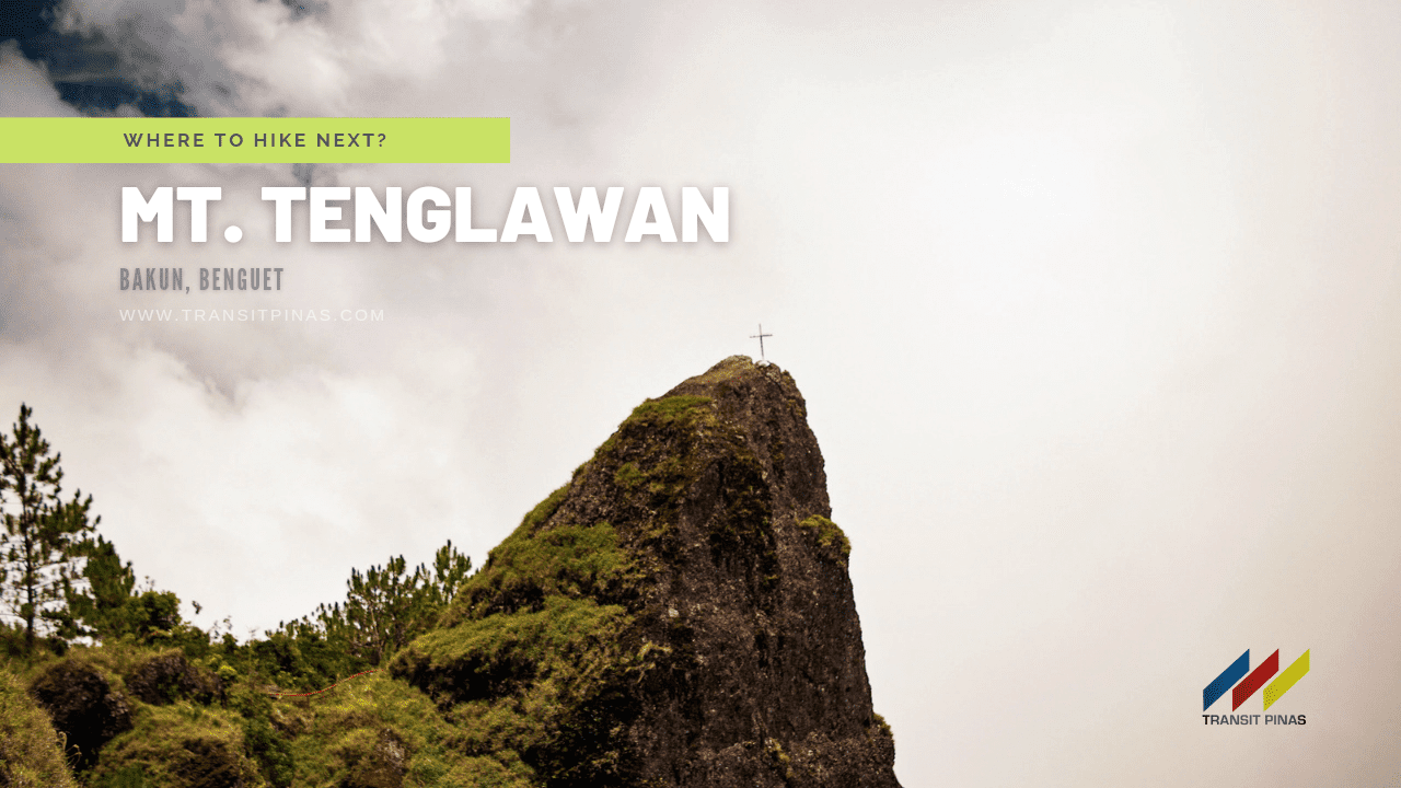
Mt. Tenglawan in Bakun, Benguet, iconic for its “Carrot Peak”, arguably, is the hardest and farthest of the Bakun Trio mountains from Bakun Poblacion.
Bakun in Benguet is known for its “Rocky Wall of Beauties”. Moreover, Bakun Poblacion sits on top of a plateau surrounded by rocky promontories. Consequently, these sentinels turn into crying mountains during the monsoon season as hundreds of waterfalls seem to weep over the sheer ravines.
Let us take you on a day hike of Bakun’s devil mountain – Mt. Tenglawan!
Trail Notes
MT. TENGLAWAN
Bakun, Benguet
Jump-off point: Poblacion, Bakun, Benguet
Alternate jumpoff: Brgy.Sinacbat, Bakun, Benguet
LLA: 1,943MASL
Days required / Hours to summit: 1-2 days / 2-4 hours
Specs: Minor climb, Difficulty 5/9, Trail class 1-3
Features: Carrot Peak, Pine Forests, scenic views of Benguet, and coastal communities of Ilocos Sur
Last updated: May 22, 2022
![]()

Brgy. Sinacbat
As of writing, Bakun Tourism opened Mt. Tenglawan to mountaineers and promoted their farthest barangay, Brgy. Sinacbat as the jump-off point; which is fairly nearer to the summit. In addition, this barangay is around 30+ kilometers from Brgy. Gambang and passes through single-lane concrete roads with dirt roads on most parts.
![]()
It is way off the Ampusungan, Dada, and Poblacion route to Mt. Tenglawan and I must say, least friendly on our rented van. We suggest arranging transportation with Brgy. Sinacbat Officials and ask to be picked up in Sitio Dalipey (pronounced da-li-poy).
![]()
![]()
![]()

At around 08:00 AM we started the hike from the Barangay Hall of Sinacbat and half an hour later, we arrived at Sitio Lupunan where we had breakfast. A few houses are scattered and perched along vegetable plantations.
![]()
![]()
![]()
![]()
As we resumed our ascent from Sitio Lupunan, the trail started to gradually rise with the view of the sheer cliff face of Mt. Tenglawan and the rocky promontory on top, that is the Carrot Peak!
![]()
![]()
![]()
![]()
![]()
![]()
![]()
Durungawan ni Jose
As we neared the foot of Mt. Tenglawan, we started to descend around the foot of the mountain. The clouds aren’t present that day and the heat began to become unbearable.
![]()
![]()
Two hours from Sinacbat, we ascended “Hagdan ni Bulilit” which is a concrete staircase with steel railings embedded on the side of the mountain.
![]()
![]()
The vegetable terraces and grassy landscape now turned into a Pine Forest. The area offered refuge from the heat of the morning sun. Also, the scent of pine and the cool temperature were a rather refreshing treat for us.
![]()
![]()
Continuing, we arrived at the last water source at around 1,720 MASL which is locally called the Bathtub (Km. 6, 1,720MASL). After refilling our water containers, we soldiered on to the Campsite (Km. 6.7, 1,830MASL).
![]()
![]()
![]()
![]()
![]()
![]()
![]()
![]()
![]()
![]()
In no time, with just a few minutes of rest on this steep assault, we finally arrived at the summit of Mt. Tenglawan at 1,943 MASL after 3.5 hours from Brgy. Sinacbat!
![]()
![]()
![]()
![]()
Unfortunately, the sun was already high enough that the clouds started to obscure the Carrot Peak. Also, the campsite with railings at the very summit is called by the locals as Durungawan ni Jose.
![]()
![]()
![]()
![]()
![]()
One must exercise caution when scaling the Carrot Peak as it has a steep drop on all sides. Moreover, be careful not to stand on the cross marker on top as it was struck by lightning causing a crack on the rock surface. Furthermore, the rock where it was fixed upon can get dislodged anytime.
![]()
![]()
The Devil Within
Kan-kanaeys consider Mt. Tenglawan as a sacred mountain. Further, if there is a Mt. Banahaw to a Mt. Cristobal, then there is a Mt. Kabunian to a Mt. Tenglawan.
![]()
![]()
It is said to be home to the god Insaking, the king of evil spirits. In fact, locals would point out that from Sitio Lupunan, the summit looks like a half face of the devil; the Carrot Peak being the horn.
![]()
![]()
Mt. Tenglawan is one of the best places in western Benguet that offers views of Ilocos coastal areas and its lowlands. Apart from this, from its summit, we were rewarded with the sweeping panoramic views of the mountains surrounding Bakun Poblacion such as Mt. Lobo, Mt. Kabunian, Mt. Data, and Mt. Osdung in the southeast. But then the clouds came sweeping down.
![]()
![]()
![]()
The Poblacion is characterized by flat pastoral fields with several rice terraces along the edges of the community.
![]()
![]()
Since this was a day hike, we went down at around 01:15 in the afternoon and were met by a downpour as we arrived in Sitio Lupunan. Eventually, we got back to the Brgy. Hall and we rushed back to Manila as it was the National Election the following day. All iz well!
How to Get There
-
Mt. Tenglawan (1,943 MASL) is located in Bakun, Benguet
-
From Manila, take a bus bound for Baguio City (246 kilometers, 4.5 hours travel time)
-
From Baguio City, transfer to a taxi and asked to be dropped at the jeep terminal bound for Bakun Poblacion in La Trinidad, Benguet. This terminal is between Kenwayne Commercial and Dap-ayan Restaurant. In addition, there are only a few trips a day and it leaves very early in the morning from 5 am to 7 am, depending on the number of passengers. (82 kilometers, 3-4 hours travel time)
-
Alternatively, at the Slaughter House terminal, take any bus bound for Buguias, Benguet, or Bontoc, Mountain Province, and asked to be dropped off at Bakun-Kibungan Crossing or Brgy. Hall of Gambang. Just make sure that you contacted Bakun Tourism before your trip so they can arrange transportation for you (66 kilometers, 2-3 hours travel time)


-
Rates and fees:
-
Mountain Guide: 1,200php/group of 6 people (6 hours)
-
Overtime Fee: 100php/hours
-
Environmental Fee (Brgy. Gambang): 140php/person
-
Environmental Fee (Brgy. Sinacbat): 100php/person
-
Lodging Fee (Brgy. Sinacbat): 160php/person
-
![]()
-
The mountain has two (2) jump-off points:
-
Bakun, Poblacion – the traditional trail from Bakun town proper
-
Trail Length: 12 kilometers one way (data from Maps.me)
-
Elevation Gain – 1,033 meters
-
-
Brgy. Sinacbat, Bakun – the new jump-off point opened by the tourism (May 2022)
-
Trail Length: 6.60 kilometers one way
-
Elevation Gain: +/- 500 meters
-
-
![]()
-
Contact Persons:
-
Mr. Alvin Comila – Bakun Municipal Tourism Officer
-
0966 264 1458 (Globe)
-
0938 092 5115 (Talk N Text)
-
Facebook Page: Bakun Tourism
-
-
Mr. Rodnie Benny – Brgy. Sinacbat Secretary
-
0920 845 5389
-
Facebook Account: Rodnie Benny
-
-
-
There are two water sources along the trail at Km. 4 (at Sitio Lupunan) and Km. 6.0 (at the spring/Bathtub)
- This is an organized event by Lilang Gala, for more climb schedules you can message them here: Lilang Gala
Itinerary and Expenses
Day 0
0900 Meet-up in Greenfields District, Mandaluyong City
Day 01
0930 Depart for Bakun, Benguet
0445 Registration at Brgy. Gambang
0515 Resume trip to Brgy. Sinacbat
0720 Arrival at Brgy. Hall of Sinacbat, Bakun, Benguet
0800 Start Trek (Km. 0, 1700MASL)
0830 Sitio Lupunan (Km 4.0, 1,600 MASL)
0945 Start of Assault (Km. 5.2, 1,510 MASL)
1000 Hagdan ni Bulilit/Railings (1,570 MASL)
1020 Water Source/ Bathtub (Km. 6, 1,720MASL)
1110 Campsite (Km. 6.7, 1,830MASL)
1130 Summit of Mt. Tenglawan (Km. 6.67, 1,983 MASL)
1315 Start descent
1345 Water Source/ Bathtub
1400 Hagdan ni Bulilit/Railings
1600 Sinacbat Brgy. Hall, tidy up
1630 Late lunch
1800 Depart for Baguio City
Day02
0300 Arrival in Manila
 Updated May 22, 2022

