
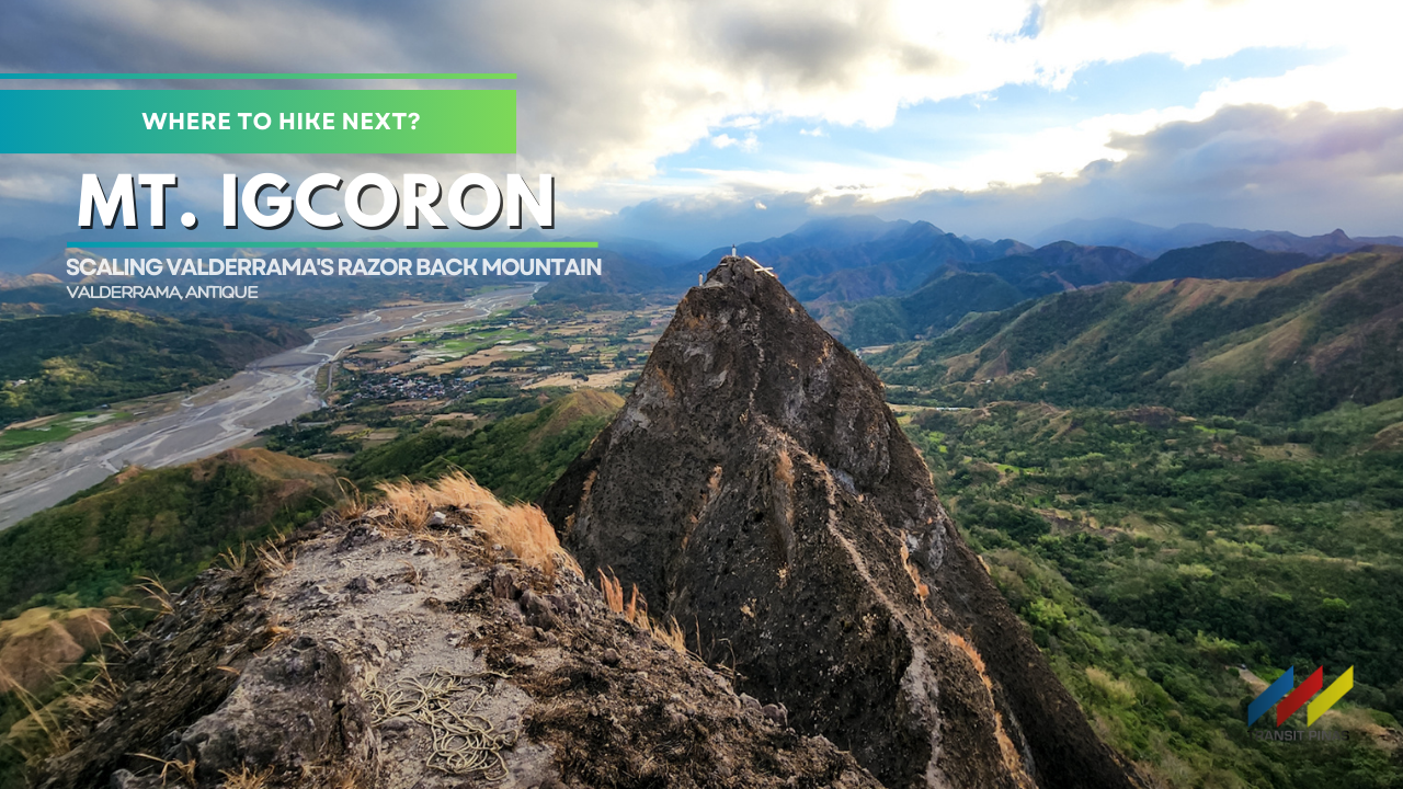
Mt. Igcoron (600MASL) | Scaling Valderrama’s Razor Back Mountain
Valderrama, Antique: It’s all fun at first but not until you reach the last segment of the knife-edge trail of Mt. Igcoron. This will keep you hanging on for your dear life and is proof that mountains should never be underestimated.

In this adventure, let us take you to the razor-back mountain of Antique.


Let’s go!
MT. IGCORON
Valderrama, Antique
Major jump-off: Brgy. Binanogan, Valderrama, Antique
LLA: 10° 58′ 51.6576″, 122° 6′ 54.9″, 600 MASL
Hours to summit / Days required: 2-3 hours / 1-2 days
Specs: Minor Climb, Difficulty 4/9, Trail class 3

—
Valderrama
It was past lunchtime when we arrived in Brgy. Binanogan, we decided to rest for a while before starting our trek by three in the afternoon. We were welcomed by our guide Ervin and made the necessary preparations before the hike.


Farming is still the norm here and is evident with the rice terraces that surround the whole area.

We had to hop over canals and streams before reaching terraces with muddy embankments that were too narrow to walk on so we had to keep our balance. Didn’t know that this would be very useful in scaling the knife-edge sections of Mt. Igcoron.


Ahead of us, the looming peaks of Mt. Igcoron, like an ancient sentinel, welcomed us. But it was not a happy sight. We thought it would be lush with the overgrowth of cogon grass, but this time, grassfire was clawing its deadly flames up to the summit.


An hour into the trek, we were thankful to have some shade as we entered the forested part of the trail. The streams and small waterfalls in this part have dried up and we can’t refill our water canteens.

Rice Terraces and Grass Fires
At first, we thought that the summit was the pointed peak from the rice terraces, but we were wrong. Ervin, our guide, told us that it was just a part of Mt. Igcoron, and the trail there needed equipment to scale. So instead of climbing over the rock pinnacles, we had to go around and follow the base of the mountain that leads to a gradual slope where climbing is possible.

The majority of the trail is now open and the scorching afternoon sun added to the challenge. The crackle and sizzle of the ongoing grassfire made me wonder if this was man-made or if it just naturally occurred.


There are more gentle downhills and steep inclines before reaching a hut at the foot of the campsite. In here we took a quick break as we cooled down for a while. Some livestock and monkeys kept us company before dealing with the final steep path to the campsite.

Billion Star Accommodation
A few minutes in, we continued to soldier on to catch the sunset at the campsite. Exhausting as it is, strong gusts of wind pushed us further up until we saw the sprawling Valderrama Valley behind us. What a treat!


We then reached the campsite after an hour and a half from the jump-off point. It was wide enough to accommodate at least a hundred tents. Then not from afar there’s a house with a terraced land where they plant rootcrops and rice.


Night time came, and we prepared a whole native Chicken Adobo all to ourselves. The cloud cover gave way and our billion-star accommodation made our camp even more magical.


I would give up everything for this because this scene right before our eyes is what stuff of our outdoor dreams are made of.


Vertigo- Inducing
The following morning, we woke up early for our summit assault. Albeit the strong winds and biting cold that kept us awake that night, our spirits were high as we ascended the steep slope that leads to the summit of Mt. Igcoron. We had to scramble our way up slowly as one small mistake might send you hurtling down back to the campsite.

The narrow trail at the slope of Mt. Igcoron is mostly loose soil and devoid of grass, thankfully there are solid rocks that serve as footholds as we navigate the now-becoming dangerous sections of the climb.

A grassy shoulder emerged, and what I thought was another tricky part is now the ridge that offers a sweeping view of the municipality of Valderrama and the wide Kangaranan River that flows to the Sulu Sea. I was feeling ecstatic at that point!


But it was still not the summit, roughly around a hundred meters from where we were. My friend decided not to push through due to the vertigo-inducing cliffs.


Knife-Edge
I was excited so I didn’t waste any time and marched to the summit. As I tread gradually along the path, menacing as it looks without the grass, the knife-edge trail is becoming more and more pronounced.


It was the thinnest trail I have experienced to date, so narrow that you can straddle some parts of it with a hundred-meter drop on both sides!


I had to be extremely careful as I managed my way to the peak. The deep ravine on both sides was terrifying, and even made more challenging by sudden blows of strong winds.

With a few shaky steps, while holding on to rocks for support, my guide and I finally made it to the summit of Mt. Igcoron!

Mt. Igcoron Summit
The White Cross planted by a missionary a few years ago on the other windswept peak got knocked off by strong winds. The tourism office also advised that it is prohibited to climb the other peak due to the absence of grass that can serve as support when climbing.


Risking our life just to get here is an exhilarating experience when you are rewarded with views such as this!


Mt. Igcoron was named as such because of a story passed down by the elders telling of a great flood that submerged the whole island. At the time, it was only the peaks of Mt. Igcoron and Mt. Igduao that jutted out of the water. Mt. Igcoron looked like a pot, and in their language, it was Coron/Koron.

The other prominent peak was where the villagers took refuge, thus from the word Duao which means viewpoint or a lookout place.

Soon, we had to go down, which was even more difficult than going up. Overall, it was such a nice experience and a reminder that each mountain is unique and has its beauty that we should appreciate very deeply.


Valderrama is a promising place in Antique that is full of surprises and we will keep on coming back for more.


Thank you to Sir Ben Pagayonon and Ms. Joy Yucom for assisting us on this hike. And best wishes to our guide Sir John Ervin who just got married a few days after our hike. Cheers!

Padayon!
How to Get There
- Mt. Igcoron is located in Valderrama, Antique with its main jump-off point at Brgy. Binanogan
- From Manila, the nearest airport is the Godofredo Ramos Airport in Caticlan and Kalibo International Airport.
- Cebu Pacific:
- Manila-Caticlan-Manila – 10x Daily
- Manila-Kalibo-Manila – Daily
- Philippine Airlines
- Manila-Caticlan-Manila – 6x Daily
- Manila-Kalibo-Manila – Daily
- Cebu Pacific:
- This applies to both airports: transfer to commuter vans or Ceres buses bound for San Jose Antique or Iloilo City. Travel time is around 2-3 hours depending on traffic conditions.
- Our staging point is from Kalibo, Aklan, and rode a van bound for San Jose. (2.5 hours travel time (143 kilometers), the fare is 350php/pax)
- Ask to be dropped off at Ilaures Crossing in Bugasong then transfer to any tricycle at the terminal and tell the driver to drop you off at Valderrama Police Station. (Travel time: 30 minutes (14 kilometers), the fare is at 100php/pax, a minimum of 3 pax per trip)
- Meet your contact at PNP Valderrama register at the Police Station and log in at the Tourism Office. Fees to be collected:
- Registration Fee:150php/pax
- Environmental Fee: 30php/pax
- Guide Fee: 1500php/5 pax for overnight climbs

- From the police station, take another tricycle to the jump-off point in Brgy. Binanogan.
- Contact Details:
- Valderrama Tourism – https://www.facebook.com/profile.php?id=100087570763046&sk=about
- Mt. Igcoron Hiking Guide/ Ben Pagayonan – https://www.facebook.com/benthehiker
- Joy Yucom – https://www.facebook.com/crizyucom
- John Ervin Salvador – https://www.facebook.com/profile.php?id=100082235764248
- The hike takes around 2-3 hours from the jump-off point.
- There are several water sources but none at the campsite, you may request water for cooking from your guide which is 15 minutes away from the camp.
- There’s no signal at the campsite, only at the summit.
- Practice LNT Principles at all times.
Itinerary and Expenses
Mt. Igcoron Overnight Climb
DAY 01
1000 Kalibo, Aklan, Van to Bugasong, Antique (350php/pax)
1230 Ilaures Crossing, tricycle to Valderrama (300php/trip)
1300 Valderrama Police Station, register
1330 Buy supplies, lunch, tricycle to jumpoff
1430 Brgy. Binanogan jump-off point
1530 Start Hike
1645 Kubo (430MASL)
1700 Campsite (480MASL), set-up camp
1900 Dinner, socials
2300 Lights off
DAY 02
0430 Wake-up
0545 Start summit assault
0620 Mt. Igcoron Summit (600MASL)
0830 Back at the camp site, breakfast, break camp
0930 Start descent
1030 Jump-off point, wash-up
1200 Tricycle to Ilaures Crossing (400php/trip)
1245 Ilaures Crossing, wait for vans or buses to your preferred sidetrip
Extend Your Trip
- Mt. Igmatongtong (799+), Antique’s Trails of the Iraynon-Bukidnon
- Mt. Madjaas (2,117MASL) – A Tough Ascent into Sidapa’s Hostile Realm
- Mt. Napulak (1,239+), Iloilo | A Journey to the Nipple Peak

Mt. Igcoron (600MASL)| Scaling Valderrama’s Razor Back Mountain
 Updated February 28, 2024


