
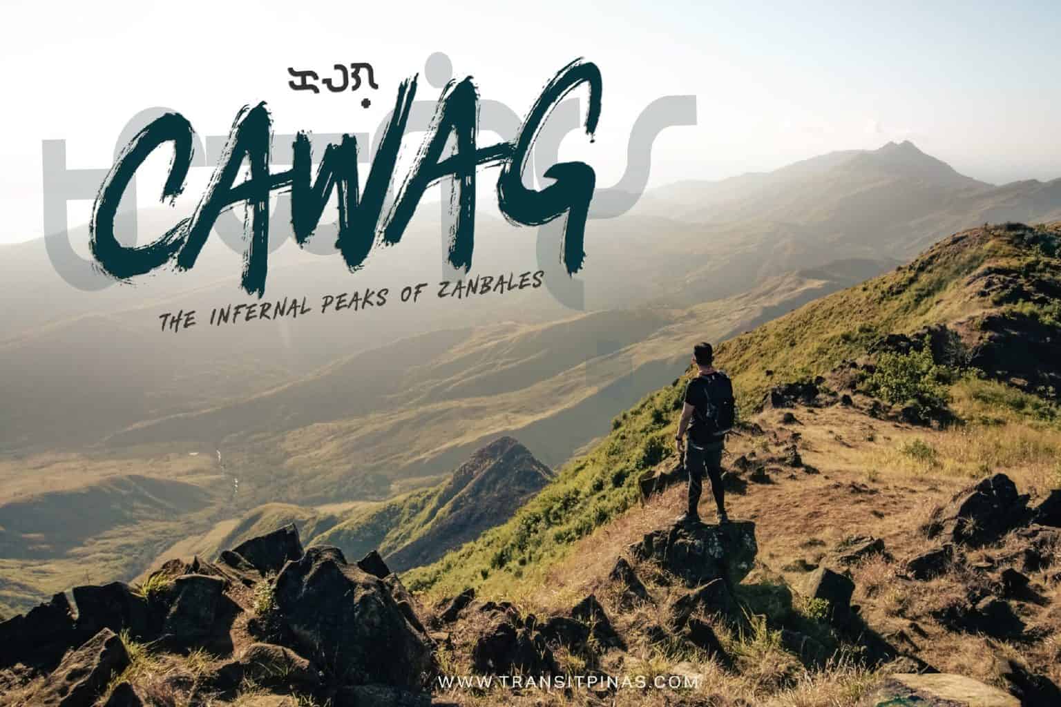
The Infernal Peaks of Zambales | Cawag Hexalogy
“The best time to climb the mountains of Cawag, Zambales is during the night”
This statement always proves to be correct whenever you finish the infernal hike to the mountains of Cawag. The hike lasts for 14-18hrs on average. Most of the trail passes through barren grasslands with no tree cover.

There’s no shade to take refuge on a hot summer afternoon. I’ve done this hike for three times now but still, I never learned the lesson ‘cause I am always coming back for more (body pains).
Cawag Coastal Mountains Traverse Day Hike
Subic, Zambales
Mt. Balingkilat (1,100+)
Mt. Bira-Bira (450+)
Mt. Naulaw (450+)
Mt. Dayungan (935+)
Mt. Cinco Picos (881+)
Mt. Redondo (660+)
Jump-off point: Sitio Cawag Settlement, Subic, Zambales
LLA: 14.89 N, 120.11 E
Exit Point: Subic Zambales
14.84 N, 120.21 E, Subic, Zambales
Days required/ hours to finish: 1-2 days/ 14-18hrs
Features: Scenic views of the coastal mountains and coves of Zambales
Specs: Major Climb, Difficulty 7/9, Trail Class 1-4
Cumulative elevation gain: 1,930 meters
Total Trail Length: 26.2 kilometers
***This is an account of my third attempt in doing the Cawag Hexalogy Day Hike last February 2019. This entry contains details of the hike, sample budget, itinerary and travel guide.
Sunrise at the Mountain of Thunder
At the southwestern portion of Zambales bordering the town of Subic lies the coastal mountains of Cawag. The area is a haven for outdoor adventures. There’s the volcanic sands and beaches fringed with Agoho Trees in the secluded coves of San Antonio. A number of open trails with some seasonal waterfalls, towering mountains and peaks.

Among the many scenic trails is the hardest one to finish, the so called Cawag Hexalogy. This hike encompasses six mountains namely – Mts. Balingkilat, Bira-Bira, Naulaw, Dayungan, Cinco Picos and Redondo.
Around 03:00 in the morning we started our hike. The trail at the initial part are open grasslands and several streams on relatively flat terrain. An hour and a half, while only relying heavily on our headlamps for illumination, we rested for a bit at the first watersource.

From the first rest stop, the sharp assault to Mt. Balingkilat started. Trail is composed of boulders, tall grasses and narrow foot paths, with most parts edging closer to steep inclines. The morning twilight broke off as the sun slowly bobbed its head out of the horizon. We witnessed the sunrise during the ascent and finally reached our first peak for the day at 0640am.


The Infernal March to Mt. Dayungan
Inarguably, the summit of Mt. Balingkilat offers one of the best views in Luzon.


There’s a 360 degree sweeping views of the secluded coves of Anawangin and Nagsasa to the west. To the north is the mighty ridges of Mt. Mabanban, to the east are the low lying mountains and communities of Zambales. Then the Grande Island of Subic Bay lies on the southern flank.


From Mt. Balingkilat, a steep descent through small to massive boulders awaits. The sun didn’t take long enough to warm up – the scorch trials has begun. No clouds are in sight, and the boulders proved to be taxing, as we had to carefully scramble through them while going down. Mt. Bira-Bira was just nearby, but the peak was badly burnt, charred grasses welcomed us at around 08:30 am.


Our water supply is limited so we can only take sips during quick breaks. Around 10:00am we finally reached our third peak for the day, Mt. Naulaw. The steel communication tower that once stood mightily is now beyond disrepair, while there’s no trace of the Nipa Hut where we used to eat and rest for a while.


The hot and oppressing heat’s now on its peak. Around 10:30am we sought refuge at the creek at the base of Mt. Dayungan to have our early lunch and rest for a while. I was already asking myself again why I am doing this again and again, 11:00am came and we had no choice but to continue towards Mt. Dayungan.


Clouds started to roll for a while as we ascended towards Mt. Dayungan, it was a slow march as if we were grilled slowly for our tender meats. I failed to reach the summit and opted to access the ridge connecting to Mt. Cinco Picos.
The Long Walk Home: Mt. Redondo
Around 02:00pm, I can now hear colors and see sounds. Kidding aside, it was exhausting at that point on as we arrive on our fifth mountain for the day, Mt. Cinco Picos. The capsite is the only accessible area as of the moment, and even if it opens, you still have to do a backtrail from where you started.


Then comes the most dreaded part of Cawag Hexalogy, the looooong way to Mt. Redondo. Dwarfed by his mighty neighbors, Mt. Redondo is composed mostly of rolling terrains covered in tall grasses. The gentle slopes kept on going up and down, just when you’re about to rest, there comes another gradual assault.

Three hours after the descent from Cinco Picos campsite, we have finally arrived at our very last peak, Mt. Redondo. This was the first time I was able to get here with the sun still up on the horizon. Probably because I skipped the summit of Mt. Dayungan per se.

We kept our distance close at this point because dusk started and one can get lost in the monotonous but winding grassland. It took us another hour before reaching the jump-off point at the other side of Subic Bay.
We completed the Cawag Hexalogy day hike after fifteen (15) hours. This required a Mang Inasal PM 1.5 celebration.
Big thanks to the Team Green Outdoor Tribe and Kap Jaime Dequinon for organizing this Cawag Hexalogy hike.

How to Get There
If doing the Cawag Hexalogy DIY way:
- From Manila, take any Olongapo bound buses and alight at Subic, Zambales town proper to meet your guide. The usual meeting place is at the Subic Fire Station where registration is mandatory
- Victory Liner Bus in Pasay, Cubao, and Caloocan (Monumento) departs hourly to Olongapo
- Pasay to Olongapo via Dau/SCTEX – 296php
- Pasay to Olongapo via San Fernando – 237php
- Travel time is 3-5hrs depending on traffic conditions
- Another 20mins of travel time before arriving at Sitio Cawag.
- Registration Fee: 60php/pax, Guide Fee: 500php/mountain, guide ratio is 1:5


Itinerary and Expenses:
Cawag Hexalogy Day Hike
Day 0
2000 Cubao, Quezon City Meet-up
2200 Depart for Subic, Zambales
Day 01
0130 Arrival at Sitio Cawag (secure guide, orientation)
0300 Start Trek
0430 First water source at Kawayanan
0440 Resume trek, start assault to Mt. Balingkilat
0600 Mt. Balingkilat summit, breakfast
0700 Resume trek
0830 Mt. Bira-Bira Summit
1000 Mt. Naulaw Summit
1030 Second water source, early lunch
1100 resume
1230 Mt. Dayungan Summit
1400 Cinco Picos Campsite
1645 Mt. Redondo Summit
1700 Start descent
1800 Arrival at jump-off point, dinner, tidy-up
2230 Depart for Manila
Day 02
0300 Back at Manila
Total Damage: 1,600php package tour c/o Jaime Dequinon of Green Outdoor Tribe


