
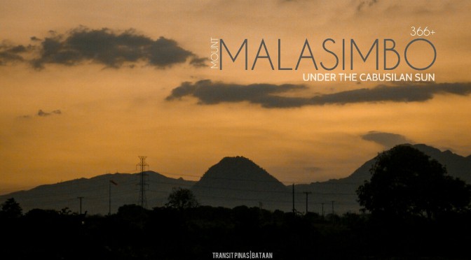
Under the Cabusilan Sun – Mt. Malasimbo (366+), Bataan
At the heart of Dinalupihan in Bataan, lies a hat shaped mountain called as Mt. Malasimbo.
View this post on Instagram
Locals commonly refer to as the Little Mayon due to its conical shape that resembles that of the active volcano in Albay. In fact, I have always noticed this mountain along the SCTEX on countless trips to Bataan and Zambales, so this time, I did a spur of the moment visit on top of this little wonder.

MT. MALASIMBO
Dinalupihan, Bataan
Major jump-off: Brgy. Bayan-bayanan, Dinalupihan Bataan
LLA: 14°53’13” N, 120°25’10” E, 366MASL
Days required / Hours to summit: 1day / 3-4 hours
Specs: Minor Climb, Difficulty 4/9 ( Subjective ) , Trail class 1-3
Bayan-Bayanan
Coming from Pampanga, I took the Bataan bound Genesis Bus and alighted at Luacan in Dinalupihan. The jump-off point is in Brgy. Jose Payumo and without I hailed a tricycle to bring me to the Brgy. Hall. I was hoping to secure a guide and also to register.
Upon arrival in Payumo, their Brgy. Captain told me to just access the trail in Brgy. Bayan-Bayanan since it is much more established compared to the trail in Payumo. He says that is very steep and has some portions where accidents did happened in the past.
Quite dissappointed with the turn-out of the visit, I returned back to the main highway. From there I flagged another tricycle to bring me to Brgy. Bayan-Bayanan, which is several kilometers away and is just adjacent to Brgy. Pita.

Upon arrival, their Barangay Secretary and a councilor welcomed me and asked what is my purpose of the visit. They said that hiking activities are only allowed during the Holy Week!
They are also asking for the permit from the NCIP Office (National Commission on Indigenous People) if I have one with me. If I failed to have one, I still have to get back to Dinalupihan to secure the permit. Since the trail leading to the summit is an IP Domain, entry to the said areas are strictly prohibited unless approved by the tribal chieftain.
Luckily that day, their chieftain went down to attend a meeting with the municipal officials. At first I thought they weren’t going to allow me to go up, but eventually they permitted me. But this is on two conditions: first is to go down the same day and just take photos, second is to inform anyone who hikes up through the Bayan-bayanan trail to secure a permit first.

It is also good to notice that the Barangay officials now are not just the “Unat” or the straight haired locals. But also it is now composed of the “Kulot” or the Aeta Tribal leaders which is good, according to Nanay Leonora. Since they’re now given the platform to voice out their concerns and not just be forgotten by the rest of the world.
I had fun and pleasure talking with Ms. Leonora Montemayor, a “Kulot” Barangay kagawad who seems very happy with her disposition in life now. She is hoping someday that stereotypes regarding races, skin color, tribal affiliation and hair be forgotten someday. Moreover, the term “these people” eventually changes into “you, me, us people as one”.
It seems a thought too far-fetched now, she said, but she was highly optimistic that as time goes by, acceptance will be widely felt.

Approved!
Ecstatic upon hearing the good news, they just told me to just follow the trail leading to the summit. It is mostly straightforward since they can’t find anyone to guide me that day. It is also worth noting that tourism activities on this part of Mt. Malasimbo is still not developed.
One can also try the harder route which is in Brgy. Jose Payumo that is open to the public but is much more harder as locals tend to suggest. The sun was already scorching hot at 10:00 in the morning, and no water sources are found along the trail. Also, I felt quite uneasy hiking alone in this part of the mountain.
I got halfway through by myself, and the foot path was not entirely misleading. I arrived into a hut where two kids were enjoying green mangoes all to themselves.


Resuming the trek, tree covers are becoming lesser and lesser by the minute, and grasses are growing even more taller. An hour and a half passed since starting, I arrived into a Banana plantation where the trail is surprisingly steep on this portion. Ascending became challenging and exhausting, partnering it with the intense heat from the sun.
The steep trail is covered in loose sand and is very unstable and slippery at some parts. The entire assault took me almost an hour before I finally reached the summit. Trees are scattered but some trees are large enough to provide shade on this blistering heat.

Summit
If the climb seems fairly easy, one can do a traverse to the three other peaks. But doing it so needs special arrangement from the Barangay of Bayan-bayanan.
From either Mt. Malasimbo or the Barangay Proper, Mt. Terranos is two to three hours away in moderate pacing. With the same set-up of almost open grassy trails, this peak is also an Aeta community where water sources are present. Then the other peak includes Mt. Kihandal, which is also two hours away and has a tongue shaped like boulder at the summit. There is also Mt. Tambo but is said to be three hours away from Mt. Kihandal.


The view from the top was rewarding and views of the landscapes and mountain ranges at this portion of the Central Luzon awaits.


From where I took a nap, some rock formations beside the cliff are good vantage points to view the surrounding plains and mountain peaks.

The Mount Natib complex stretches from Dinalupihan-Hermosa area down to Balanga while the almost untouched Cabusilan Mountain range cradling the infamous Pinatubo Volcano lies sentinel among the mighty peaks of the range.

How To Get There
- From Manila take any Bataan or Zambales bound bus and alight at Dinalupihan, Bataan. (130-150php, 2-3hrs travel time)
- Flag a tricycle to take you to Brgy. Bayan-bayanan and alight at the Brgy. Hall. (100-150php/trip, 20 minutes travel time)
Hike Tips
- Coordinate with the local barangay officials before attempting to hike Mt. Malasimbo or nearby peaks, you can contact Ms. Fe Paguio (Barangay Secretary at 0929-173-8546)
- They will ask for a permit from the NCIP so better coordinate with Ms. Fe on how to get one if they will insist to.
- The trail is not entirely covered by trees and halfway through the hike, you will be emerging into Banana plantations that will make the hike very hot especially during summer afternoons.
- No water sources going to the summit of Mt. Malasimbo, but you can politely ask the locals for water since there are several huts halfway to the summit.
- Be respectful of the locals and their ways, always practice LNT Principles.
Planning to scale Mt. Malasimbo soon? Ask us anything on the comments section below!

 Updated as of May 08, 2018

