
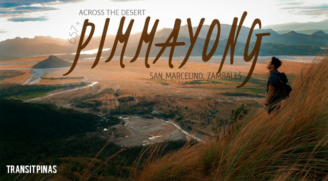
Across The Desert – Mt. Pimmayong, Zambales
Mt. Pimmayong
San Marcelino, Zambales
Jump-off Point: Sitio Ilong, Brgy. Sta. Fe, San Marcelino Zambales
Latitude: 15° 1′ 48.7″ (15.0302°) north
Longitude: 120° 10′ 50.2″ (120.1806°) east
Elevation: 657 MASL (2,156 feet)
Description: Minor Climb, Grassy Plains, Forest, scenic views of Cabusilan Range, Cawag Mountains, Lake Mapanuepe, Lahar Flows from Mt. Pinatubo
Ever heard of San Marcelino in Zambales?
Usually travelers and adventure seekers alike just pass by this sleepy town. Typical destinations are the secluded coves and mountains of San Antonio, the beaches of San Narciso, islands of Candelaria, or the two-thousander, Mt. Tapulao in Palauig. The town of San Marcelino is approximately 150 kilometers, or 3-4 hours away from Manila.

October last year, the Tourism Office of San Marcelino opened up a new hiking trail in Brgy. Sta. Fe. It features a 360 degree view of the surrounding mountains of Cawag, Cabusilan and those in Palauig.
Moreover, San Marcelino is popular to some mountaineers who traverses Mt. Pinatubo via Delta Five or Sapang Uwak Trails from Porac, Pampanga down to Brgy. Aglao or Pili. The hike usually takes three days on otherworldly landscapes made by the devastation of the volcano on the surrounding provinces during the 1991 eruption.
We decided to visit Mt. Pimmayong after hearing this from acquaintances and luckily the Tourism Page of San Marcelino. Ms. Mikee Labio gladly assisted us on our inquiry.
The Tarudak Peak
We left Manila at exactly 12 midnight at the Caloocan bus terminal of Victory Liner. By 03:30 am, we alighted at the sleepy town of San Marcelino and crossed the street to have a quick breakfast at a convenience store.
Then Mang Gil, our contact, arrived with his tricycle. We started the trip along the cemented roads of Agpalo St. passing by some houses before leading down into the now dry Sto. Tomas River.

From the Brgy. Hall, Mang Gil then coordinated with our guide for that day. It was Joel Soler who was waiting for us since 03:00am.
We immediately started the trek. After almost an hour we reached the coldest spot in that mountain, that they call as the Bira-Bira Ridge. Contrary to the sandy forest floor at the start of the hike, this one is filled with rocks and boulders. Then we reached the campsite or the so-called Tarudak Peak, where huts and water source are provided for visitors.

The Desert Sun
From the campsite, the trail then ensued into an open road where 4×4 trucks and motorbikes could easily pass through. This is due to the government efforts to link the mountain to the low lands via an accessible route.
We did not spent that much time at the campsite since we are trying to chase the first light at the summit. After half an hour, we reached the very summit of Mt. Pimmayong, some 657 meters above sea level.


The summit is a flat grassland that towers over the great fields from down below. We were fortunate enough to witness the sunrise at the summit. The sky exploded in vibrant hues of orange and yellow as it rises over the mountains of the Cabusilan Range with the placid Lake Mapanuepe at the foot.


Then the Lahar fields of the once flowing Sto. Tomas River are illuminated turning into white and almost auburn. The lone Mt. Bagang stood as centerpiece of the whole expanse.
I must say that although the trails leading to the summit is fairly easy. Moreover, the views are rewarding enough. From there the islands of San Antonio and the Cawag Mountains are seen also with its grassy summit and ridges bowing down before the great sunrise.


Some of the adjacent localities in the area include Mt. Maquineng (5kms to the North), Mt. Piluca (5kms to the Northeast), Mt. Bagang, and Simiminoblan Hill (5kms to the Southwest).
Another interesting sight is the Lake Mapanuepe, this was once called the Mapanuepe Valley where a mining corporation set-up a housing community for its workers. But on that fateful year of 1991, the Mt. Pinatubo erupted and the lahar following the eruption blocked the drainage of Mapanuepe River, south of the volcano, flooding Mapanuepe Valley together with its settlements.

This eventually caused flooding of the whole community, submerging homes deep into the placid water of the now, Mapanuepe Lake. As of today, the steeple of the church with a maroon cross still protrudes out of the water. This exudes an eerie feeling whenever you’re in the area.


The desert sun has risen over the coastal mountains of Zambales. I am hoping soon this would be a hit destination to help the locals within the community. We then got back to the campsite in Tarudak Peak and slept a bit before eventually descending to Sitio Ilong by 11:00 in the morning.


Bathrooms were closed that time since it is a Sunday and only a two groups visited that day. We decided to tidy up at our next destination and we still have to cross the lahar field going back to the highway of San Marcelino. Along the way, we kept on pushing our tricycle after being stuck several times on soft lahar terrain. Even encountered several dust devils blocking our way.


