
Mt. Asog (1,140+) | Iriga’s Horseshoe Volcano
Mt. Asog or Mt. Iriga is a dormant stratovolcano in Camarines Sur that is often outshined by the equally beautiful Mayon Volcano and Mt. Isarog.
![]()
But this mountain of the rising sun has a colorful history hiding behind its short name. Find out why in this adventure!
![]()
![]()
MT. ASOG (MT. IRIGA)
Camarines Sur
Major jump-offs: Sitio Ilian, Brgy. San Nicolas, Iriga City; Brgy. Cabatuan, Buhi
Elevation: 1,140 MASL
Days required / Hours to summit: 1-2 days / 4 hours
Specs: Minor Climb, Difficulty 4/9, Trail Class 1-4
(www.pinoymountaineer.com)
Kubo-Kubo
We arrived in Naga City early in the morning, then transferred to a van bound for Iriga City. From San Nicolas, we hired a tricycle to Sitio Ilian where we immediately started the trek after securing a guide.

The trek is somewhat easier to manage as it passes through open coconut plantations with some cow grazing over the fields. But the scorching heat of the sun might take a toll so start early if possible.
![]()
![]()
![]()
Then after the open fields, you will enter the woodlands, not exactly forested but will give you enough cover from the sun. Around an hour and a half, we reached the Kubo-Kubo area (685 MASL) which can be used as a campsite.
![]()
![]()
![]()
![]()
![]()
![]()
After the Kubo-Kubo area, the trail starts to get steeper. Also, the view gets better as the low-lying city of Iriga becomes visible from here.
![]()
![]()
![]()
![]()
![]()
![]()
Moreover, the trail is just straightforward and mostly assaults from thereon.
Horseshoe Crater
We reached the highest point of Mt. Asog’s multiple peaks, but from this point, the view is just breathtaking!
![]()
![]()
![]()
![]()
![]()
![]()
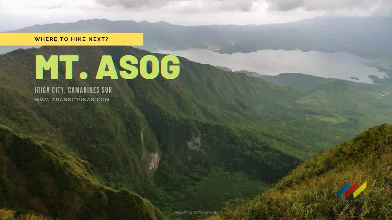
Mt. Asog/Iriga is a dormant stratovolcano with its crater shaped like a horseshoe. The base of the mountain stretches to 10 kilometers. To add, the knife-edged slopes defined the contours of this mountain as it fronts the famous Lake Buhi.
![]()
![]()
![]()
The last known activity of Mt. Asog is during 1628 and 1642, which is characterized by phreatic eruptions. The crater was formed by these explosions that led to debris avalanches.
![]()
![]()
From the summit, one can see the cone-shaped Mt. Mayon and the imposing peaks of Mt. Malinao and Mt. Masaraga on the south. Further, there is Mt. Isarog on the north; and the fairly visible Catanduanes island on the east.
![]()
![]()
![]()
![]()
The climb to Mt. Asog is fairly easy but only gets harder as the trail is exposed to the sun all the time. Mt. Asog is usually combined with Mt. Isarog in Naga City but this mountain requires a permit before the climb so plan accordingly.
Asog: Precolonial Gender Benders?
Mt. Asog was named after an ancient Datu of the Agtas named Asog. Moreover, this was also called Mt. Sumagang, which means “Mountain of the Rising Sun”.

During the pre-colonial times, the word “Asog” as much as “Babaylan” is defined as “men in the past who were like ministers of the people for their idols”. Consequently, Asogs dressed like women, tore their ears like women, imitated women’s speech and actions during rites, and did not marry women”.

This was from the “Vocabulario de la Lengua Bicol” (first published in 1754, republished in 1865) by the Franciscan Lexicographer Marcos de Lisboa.

Asogs together with the Babaylans was the divine intermediaries sought by precolonial Filipinos, some of them cross-dressed and did what women did. They believed that these spirits are neither male nor female, thus why the Asogs dressed as such. But as Christianization came, together with the churches and friars, the Asogs and Babaylans were eradicated saying they are cohorts of evil.
How to Get There
- Mt. Asog is located in Iriga City, Camarines Sur with several jump-off points:
- Ilian Trail – the easiest and more established trail closer to Iriga City
- Cabatuan Trail – the lesser-explore trail that starts at Brgy. Cabatuan in the town of Buhi. Also, this trail will give you access to the dead crater via the Esplana Campsite
- From Manila, take any buses bound for Naga – Tabaco, Legazpi, Sorsogon, Masbate, Matnog, all of these buses will have a stopover at the Naga City Central Bus Terminal
- Upon arrival at Naga City, across from the terminal is the Jesse Robredo Coliseum where the terminal of vans and jeeps are located. Right after, transfer to the ones bound for Iriga City and ask the driver to drop you off at the Brgy. Hall of San Nicolas
![]()
![]()
- Then, at Brgy. San Nicolas, transfer to another tricycle and tell them to drop you off at Sitio Ilian at the old CAFGU detachment which is now the Mt. Asog registration area
- There are no water sources along the trail
- The summit campsite at the Sitio Ilian Trail can only accommodate 2 tents
- Also, there are Limatiks and Rattan
- Signal and data reception is strong along the trail
![]()
Itinerary and Expenses
Mt. Asog/Iriga Day Hike
Day 0
2000 Depart from Manila
Day 01
0530 Arrival at Naga City, Breakfast
0630 Transfer to vans bound for Iriga City
0730 Arrival at Brgy. San Nicolas, Iriga City, transfer to a tricycle bound for Sitio Ilian
0815 Sitio Ilian, register, secure guide
0900 Start trek
1030 Rest at kubo-kubo area (685 MASL)
1220 Mt. Asog Summit (1,140 MASL)
1340 Start descent
1510 Back at jump-off point, tidy up
1540 Take tricycle to Nabua Crossing
1930 Embarcadero, Legazpi, Albay
2200 Bus back to Manila
**Mt. Asog is an easy day hike; you can partner it with the much grander Mt. Isarog in Naga City or any destination of your choice
Where to Stay
- Iriga Plaza Hotel, Iriga City, Philippines

- Max n’ Fe Apartelle, Iriga City, Philippines

- Asog County Hotel, Iriga City, Philippines

- Parkview Hotel, Iriga City, Philippines

Extend Your Trip
- Naga’s Last Refuge; Mt. Isarog (1966+), Camarines Sur
- Belle of the Pacific; Apuao Pequeña Island, Mercedes, Camarines Norte

 Updated February 21, 2017

