
Mt. Madjaas (2,117MASL) – A Tough Ascent into Sidapa’s Hostile Realm
Mt. Madjaas is one of the three mighty mountains of Antique and is considered the highest in the whole of Panay Island.

In this adventure, we had a taste of Antique’s hostile terrain: from the scorching open lowlands up to the misty and freezing montane forests of the highlands. This is definitely a dream climb for every mountaineer out there!
![]()
Come and join us in this three day climb into Sidapa’s hostile realm!
Trail Notes
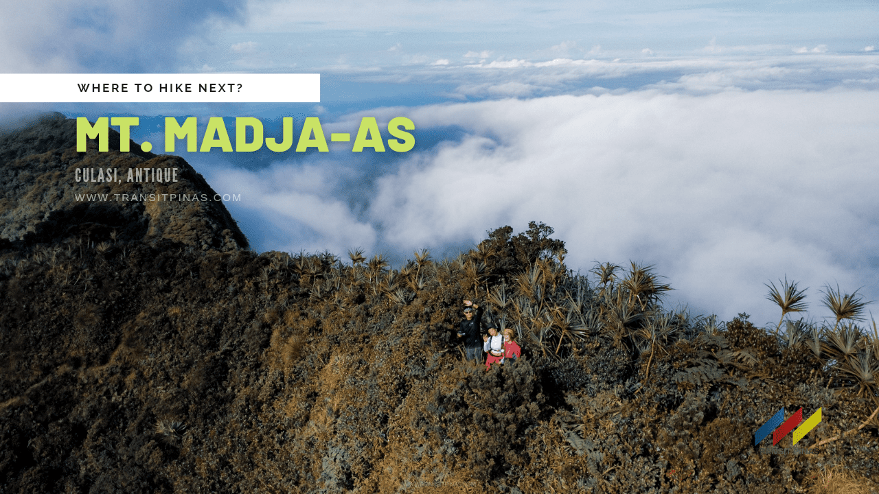
MT. MADJAAS
Culasi, Antique
Major jumpoff: Brgy. Flores, Culasi
Elevation: 2113m (HP – Panay Island)
Days required / Hours to summit: 3-4 days / 14 hours
Specs: Major climb, Difficulty 8/9, Trail class 1-4
Features: Open slopes, Mossy Forest, Waterfalls, Highest Point
(www.pinoymountaineer.com)
![]()
“you can, you should, and if you’re brave enough to start, you will.”
― On Writing: A Memoir of the Craft
Day 01 – Kamandiga Village
A tropical depression ravaged most parts of the Visayas region days before our climb, but we continued since the western part of Panay Island only experienced occasional rainfall. Moreover, there is still a go signal from the Tourism Office to climb Mt. Madjaas.
Upon arrival at Kalibo International Airport, we then transferred into a Ceres Bus that took us two hours before reaching Culasi, Antique.
![]()
![]()
We had a brief orientation at the tourism office, this is followed by logging in at the Culasi Police Station. After over an hour, we chartered habal-habal motorcycles which then took us around twenty minutes before finally setting foot in Brgy. Flores – the traditional jump-off point of Mt. Madjaas.
![]()
The mountain was already within our sight, albeit its hostile features such as its steep crags and several weeping waterfalls on its cliffs – its charm is like no other.
![]()
![]()
![]()
From Raya Tulay River, we started the adventure in high hopes that the elements will agree with us. The ground surprisingly was as dry as bone, it is as if rains never visited the area.
![]()
![]()
Then the trail started to rise gradually, from 250 MASL we carried our backpacks until we reached a small hut in Kamandiga Village (465 MASL). The rice terraces are in full bloom as farmers started to harvest rice.
![]()
Bantang River Campsite
After a short rest and refilling of our water canteens, we went up a steep open ridge. It was around lunchtime that the sun was already perched on its highest peak. But the weather was agreeing with us at that time, clouds continually gave us the cover we need while we hiked up the ridge.
![]()
![]()
A series of steep inclines after another, Mt. Madjaas rewarded us with some level terrains as we left the farmlands. Not from afar, the open sea was within sight with the white shores of Malalison Island beckoning us to come after the climb.
![]()
Thick green canopies mainly of Pine and native trees are just a few meters away, something unheard of in this part of Visayas. A cool breeze welcomed us while we went past the tree line at around 770 MASL. The level terrain suddenly switched to steep inclines, yet again, which required us at some parts to hold on to branches as the forest cover started to thicken.

Then a little over four hours from Brgy. Flores, we finally reached the junction of the Bantang River (1,236 MASL) and the old trail leading up to Mt. Nangtud.
![]()

The faint gushing of water is already heard at this part, so we rested for quite a bit until we started to descend. But the ridge leading to the campsite was unforgiving as it is mostly tackling large tree roots with a hundred-foot drop on either side. In addition, alien-like Limatiks now started to fester the trail.

Bantang River Campsite sits at 1000 MASL after almost 6 kilometers from Brgy. Flores. To add, the campsite serves as a sanctuary, as it offers unlimited water for our needs and also the tree cover that shields us from the cold winds in the morning. We set up camp and called it a day.
![]()
![]()
![]()
![]()
Day 02: Libog Falls
At around 01:00 am the following day, we woke up and prepared for our summit bid. Right after crossing the Bantang River at 03:00 am, we were already challenged by a steep vertical embankment in loose forest soil, one wrong move and you are out.
![]()
Everything was pitch black and we were so focused on the trail that we were oblivious to the features of the jungle around us. The trail continued to rise; flat sections only last for 5 seconds before another steep section comes along. Some parts are treacherous ravines that offer just a foot wide trail for hikers like us, then in some parts, there are roped segments that land into a stream at the side of a crag.
![]()
From Bantang River’s 1000MASL elevation, we arrived at Libog Falls after almost two hours, which rises to 1,530MASL.
We were already at the mercy of Mt. Madjaas’ ancient forest that day. The loam soil of the forest was soft, that at some parts it was tricky to put your full weight on it, and if the unthinkable happens, it will send you hurtling down on one of the rock faces.
![]()
Thick moss now covers the first-generation trees of the mountain. The ascent proved to be tough as nails as some sections are made of entangled roots and vines that cover what seems to be deep chasms.
![]()
False Peak – View Deck #2
The jungle abruptly ended as we ascended a 70-degree grassy ridge that led us to the second view deck (1,820 MASL) after managing to cover four kilometers that morning.
![]()
![]()
![]()
This is also called the False Peak as it will knock some sense of reality that the summit is still far away. We had our much-needed breakfast before resuming the summit bid.
![]()
![]()
![]()
To be honest, I was already quite spent that morning, knowing that the summit is still leagues away. But the sunrise and the clearing we had that morning gave us the right kind of push. Moreover, the views are spectacular – the immensity of the thick forest, the vast open sea, the shadow that Mt. Madjaas is casting against the lowlands, and the solace we found at the heart of the wilderness. We felt utterly insignificant against the grand scheme of things.
![]()
![]()
![]()
From View Deck #2 it took us around half an hour before arriving at Campsite #3 (Km 11.13, 1,800 MASL). This also serves as the last water source, so we refilled our canteens one last time.
![]()
Bonsai Forest
From the water source, just at the shoulder of the mountain ridge lies the campsite. But we carried on along the narrow trail that is once again filled with primordial trees covered in velvety moss.
![]()
![]()
The rainforest is extraordinarily thick, but my patience was already wearing thin as we negotiated the thorns and roots blocking the trail. We had to go over and under Jurassic roots and fallen tree trunks. They were the definition of really nasty, I must say.
![]()
A little over 1,880MASL at around 07:00 am we arrived at a surreal-looking Bonsai Forest. The crown shyness phenomenon is observed on the tree canopies here. It felt ethereal just to be in that peculiar landscape that day.
![]()
![]()
![]()
![]()
The gnarly-looking dwarf trees here are abundant due to the elevation and their location on this side of the mountain. Also, the trees are adorned by these strange looking pitcher plants (Nepenthes ventricosa).
![]()
![]()
![]()
![]()
The last section of the climb sent us into the knife edge ridge of Mt. Madjaas. There were some dangerous potholes along the already tapering trail.
![]()
![]()
![]()
Moreover, mossy trees are now as thick as ever, with the constant cold temperature and the high elevation, the growth and decay of these trees are indicative of a thriving biosphere.
![]()
![]()

![]()
![]()
Final Ascent Inside Siadapa’s Hostile Throne
Luckily, only brave mountaineers and hunters traverse through these trails leaving them relatively untouched.
![]()
![]()
Mother nature did all the work, it is as if entering Sidapa’s forbidden realm. Old folklore recognizes the tale of the god of death, Sidapa, who considered Mt. Madjaas as his home.
![]()
![]()
At around 09:00 in the morning, after a series of merciless ascents and agonizing descents, we finally set foot at the summit of the revered Mt. Madjaas. (Km 13.0, 2,117MASL)
![]()
![]()
The weather was forgiving enough during the duration of the climb, that not a hint of rain cloud threatened the horizon. Good thing, that there was no heavy downpour as the trail will be more brutal. We were thanking Sidapa for a very safe climb.
![]()
![]()
Just around five meters away is a small viewing deck, the clouds started to clear up, revealing swatches of mountain ranges, farmlands, and encompassing views of Culasi and its islands.
![]()
![]()
![]()
![]()
![]()
After an hour on top of the summit, we started to descend back to the Bantang River. Further, the hike was more excruciating to manage as we had to be even more extra careful in going down than going up. It took us four hours before we got back to the campsite.
![]()
![]()
We lay down happily inside our tents for a very successful summit bid of Madjaas. The following day, we broke camp and arrived at Brgy. Flores by lunchtime.
Sidapa’s Sacred Realm – A Queer Visayan Folklore
Sidapa, alone in his mighty mountain peak, fell in love with the seven moon gods as he saw them from his tall tree at the summit of Mt. Madjaas. What’s more, he then realized that the other gods also adored the deities, so he started to compete with them. Furthermore, Sidapa started to court them with songs, flowers, and fireflies atop the mountain.

The Moon God, Bulan, a young skinny beautiful boy, descended from the heavens to adore Sidapa’s gift. One night, the Bakunawa, a giant dragon-serpent also captivated by the gods, tried to swallow the moons for itself.

Sidapa saw the creature ascending into the heavens, and the god of death flew to snatch and save Bulan before the Bakunawa did. Today, it is said that the two still inhabit the summit of Mt. Madjaas.


How to Get There
- Madjaas is located in Culasi Antique, with Brgy. Flores as its traditional jump-off point
- From Manila, you can fly to Kalibo International Airport then transfer to another van/bus bound for Culasi, Antique (93kms, 2-3hrs travel time)
- via Cebu Pacific Air: Manila-Kalibo-Manila, flies daily
- via Philippine Airlines: Manila-Kalibo-Manila, flies daily
- Alternatively, you can fly to Iloilo International Airport, although this is a much longer route, flights going to and from Iloilo are much cheaper and has several flights daily. (198kms, 4-6hrs travel time)
- via Cebu Pacific Air: Manila-Iloilo-Manila, flies 3x daily
- via Cebu Philippine Airlines: Manila-Iloilo-Manila, flies 5x daily
- Upon arrival at Culasi, Antique, proceed to the Tourism Office for the registration and orientation. Right after, log in at the Culasi Police Station
- You can use the following contact details for more information:
- Street Address: Culasi Municipal Hall, LGU Culasi, Antique, Philippines
- Contact Person: Mr. John Sumanting (Culasi Tourism Officer)
- Landline: (036) 277-8167 / (036) 277-8077
- Cellphone Number: 0917-736032
- Email: johnjohnsumanting_mio@yahoo.com
- The Permit to Climb Fee is Php 150.00 per head per day. You can pay in advance by sending it via Palawan Express Pera Padala to this receiver:
- John John U. Sumanting
- Municipal Tourism Officer
- LGU Culasi, Antique
- Cell phone No.: 0916-7736032
![]()
- Other fees and expenses during the climb:
- Tricycle from Kalibo Airport to Ceres Bus Terminal: 100php
- Bus from Kalibo to Culasi via Ceres Bus: 234php
- Habal-Habal fee from Culasi Town Proper to Brgy. Flores: 350php per motorcycle
- Guide Fee: 600php/day/group (1-5pax/group)
- Porter Fee: 800php/group/day
- Signal and Data reception is available for Smart and Globe at the Junction, View Deck 2/3, at the summit, only Smart is available
- There are several water sources:
- First at Kamandiga Village, at the nipa hut resting area
- Second at Bantang River Campsite
- There are several streams where you can collect water between Bantang River and Libog Falls
- Last is at the foot of Camp 3 before the Bonsai Forest
- Mt. Madjaas is a sacred mountain. Treat it with respect and follow the Leave No Trace (LNT) Principles
- Do not climb the mountain without a permit. It’s not only unethical but also illegal. Prepare to meet stiff sanctions if you do not follow this rule.
- Our climb was organized by Summit Trekkers, they organize several climbs of Panay’s highest mountains, namely: Mt. Nangtud, Mt. Madjaas, and Mt. Baloy Daku
- You may contact them here for more details:
- Facebook Page: Summit Trekkers (Link HERE)
- Mark Anthony Torcita (Contact Number: 0998 199 3281)
- Due to the ongoing Covid-19 Pandemic, safety and health protocols are observed, here are the documents you need to prepare before the climb:
- Kalibo, Aklan Health Declaration Card – If arriving at Kalibo International Airport. Access it HERE
- S-Pass Approved Permit from the S-Pass App
- Traze Contact Tracing QR Code (Sometimes required at the airport arrival areas)
- Vaccination Card
- If not fully vaccinated, a negative RT-PCR Test is taken no later than 72hrs upon arrival
- Valid Government ID
Itinerary and Expenses
Day 01
0630 Arrival at Kalibo International Airport via Cebu Pacific
0930 Arrival at Culasi, Antique, proceed to Tourism Office
0940 Orientation
1000 Register at Culasi Police Station
1020 Habal-habal to Brgy. Flores
1040 Brgy. Flores jump-off
1100 Start trek 250MASL
1150 Kamandiga Village Rest Area, Lunch (Km 2.0, 465MASL)
1340 Treeline (Km 3.67, 770MASL)
1515 Bantang River Junction (Km 5.2, 1,236MASL)
1540 Start descent
1610 Bantang River Campsite, set up camp, free time
1900 Dinner, socials
2000 Lights off
Day 02
0115 Wake-up call, breakfast
0300 Start ascent to Mt. Madjaas Summit
0445 Libog Falls (Km 9.0, 1,530MASL)
0600 View deck 2, breakfast (Km 10.1, 1,820MASL)
0630 Resume
0650 Camp 3 (Km 11.13, 1,800MASL)
0710 Bonsai Forest (1,880MASL)
0820 View deck 3 (Km 12.70, 2,000MASL)
0915 Mt. Madjaas Summit (Km 13.0, 2,117MASL)
1030 Start descent
1200 View deck 2, Lunch
1245 Libog Falls
1430 Bantang River Campsite
1900 Dinner, socials
2100 Lights off
Day 03
0600 Wake-up call
0700 Breakfast
0810 Start descent
0845 Bantang River Junction (1,236MASL)
1010 Kamandiga Village
1030 Resume
1100 Arrival at Brgy. Flores, swim at Raya Tulay River
1120 Tidy-up at guide’s house
1300 Culasi Tourism Office, awarding of Certificates, log-out of Police Station
1400 Bus to Iloilo/Kalibo depending on your exit point
Where to Stay
- RedDoorz @ LS Suites Poblacion Culasi Antique, Antique, Philippines

- Kasa Raya Inn, Antique, Philippines

- ZEN Rooms Casa Venicia Caticlan, Malay, Philippines

- RedDoorz near Caticlan Airport, Malay, Philippines

- RedDoorz Plus near Gaisano Mall Kalibo – Vaccinated Staff, Kalibo, Philippines

- RedDoorz @ D Maagma Street – Vaccinated Staff, Kalibo, Philippines


 Updated May 04, 2022

