
The Attack of the Limatiks | Mt. Kalawitan (2,714+) Mountain Province
Mt. Kalawitan cradles an almost untouched world inside its slopes. This mountain is considered the fourth (4th) highest in Luzon. Also, it is the tenth (10th) highest mountain in the country.

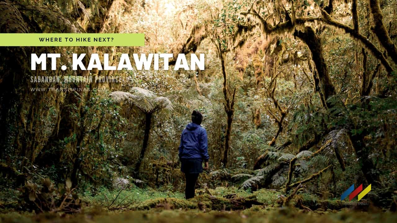
MT. KALAWITAN
Sabangan, Mt. Province
Major jumpoff: Panorama Viewpoint, Halsema Hwy, Sabangan
LLA: 2714 MASL (#10/n)
Days required / Hours to summit: 2-3* days / 6-7 hours
Specs: Major, Difficulty 5/9, Trail class 2-4
(www.pinoymountaineer.com)


Almost…
Mt. Kalawitan has been on my to-hike list ever since I started climbing. Moreover, in 2017 I was lucky enough to almost scale it but as we passed by the meandering Dagiwdiw Rice Terraces, the weather started to deteriorate rapidly. Right after we crossed the Kapangdanan River, the lodges at APA campsite were beaten brutally by the thunderstorm that we just spent the night in there and decided not to pursue the climb.

Fast forward to 2021, at the first sight of an event that will attempt to hike Mt. Kalawitan in a day, I immediately signed up!

Munna Campsite
We arrived late at Golden Farm Resort in Bontoc, Mountain Province at around 08:00 am due to some logistical problems from Manila. By 09:00 am we started the hike.

The initial part of the trail is a concrete pathway that immediately leads to the pine forests swathed by thick fog cover. The scent of pine and the chilly breeze brought back a lot of memories.


The trail from the jump-off is gradually uphill, with some parts still exposed to the sun. The eerie fog cover somewhat is reminiscent of a scene from a horror flick where you will be at the mercy of some hillbilly freaks chasing you with their butcher knives.


Three hours from the jump-off point and already gaining around 600 meters in elevation gain, we arrived at the Munna Campsite or Camp #1. This is the last part of the pine forest before entering Kalawitan’s Forest.


Juuno’s Playground
Thinking we could still have some rest as we go along, we immediately left Munna only to be welcomed by an even heavier downpour, spine-tingling cold, and yes, a throng of blood leeches.


The mossy forest, I must say, is one of the most enchanting ones I’ve seen in the Cordilleras. It may not be as grand of that in Mt. Dulang-Dulang (Adventure HERE), but I tell you not, it’s like you’ve been portaled into a new world.


Halfway to the climb at around 2100 meters is where the water source is located. The trail even becomes narrower, and the rain kept the ground even more slippery.


As a consequence of the unabated cloudburst, blood leeches or limatiks have sprung and are all waiting for their next victim. The attack of the limatiks left us all bloodied after the climb.


Around 02:00 pm we arrived at Juuno’s Playground; a dried swamp clearing surrounded by trees with rich mossy appendages.


Mateo’s Garden Camp
I can’t exactly explain it but with the trail, we covered at around 12 kilometers, the biting cold, the lack of rest, and the opportunity to grab a quick bite – we felt exhausted. Walking dead as they said, but we inched closer to the summit at a turtle-like pace.


Arriving at Mateo’s Garden Camp or Camp #2, we couldn’t even barely talk to each other. Furthermore, our hands already shriveled, our jackets were already drenched from the rain. But we mustered the courage from that one last push to the summit.


Consequently, the last 3 kilometers going to the summit, our physical and mental resources were somewhat drained. Also, several pits and traps were present along the trail. It is said to be hunter traps for wild boars and deers.
10th Highest PH Mountain
All this rich forest that we passed through eventually culminated into the summit of Mt. Kalawitan. After seven hours and 1,600 meters of elevation gain, we finally reached the highest point of Mountain Province!

The summit is quite unremarkable and is surrounded by trees. The summit landmark is a steel pole with small summit signage on it. The wind was blowing freakishly from all sides as it was accompanied by a heavy downpour. We only spent five minutes before descending.

This mountain maintains a forested peak with dwarf bamboos and trees. In addition, large portions are still a sanctuary to diverse wildlife, and also the source of water flowing to the various tributaries of the mighty Chico River.

Culture Hero and the Cordilleran Folklore
Kalawitan was derived from the Kankanaey word “Kalawit” which means to climb, which was evident when we scaled this mountain.

In addition, it is believed by the locals that the Bontoc-Igorot God – Lumawig – made mountains, one of which is Mt. Kalawitan. Folklore states that, in the beginning, the earth was flat, and then Lumawig’s sons went hunting, there was nothing to block the game, so they decided to flood the earth to form mountains. (Bacwaden 1997, 3-49)
Lumawig, a culture hero, was also instrumental in laying the foundation of a new race. It is said that a pregnant woman named Fanayan, survived the great flood at the summit of Mt. Kalawitan. She gave birth to a baby girl, then Lumawig turned the placenta into a baby boy. (Bacwaden 1997, 334)

How to Get There
- Kalawitan (2,714MASL) is located in the towns of Sabangan and Bontoc in Mountain Province, and Tinoc in Ifugao
- There are two jump-off points:
- First is at the Panorama Viewpoint in Sabangan, Mountain Province along the Halsema Highway that leads to APA Campsite
- Second, and the one we used, is at the Golden Farm Resort in Brgy. Talubin, Bontoc, Mountain Province which leads to the Munna Campsite or Camp 1
- I joined a group event by Akyat Tanaw Mountaineers to avoid the horrors of commuting during this pandemic.

- You can contact Golden Farm Resort for more info:
- Golden Farm Resort Facebook Page: goldensuccess24
- Sir Garman – 0935 665 1239
- Alternately, you can contact Bontoc Tourism Office via Ms. Elizabeth at 0929 127 0892
Travel Tips
- Kalawitan’s summit is around 6-7 hours away, 14-15 kilometers away from Golden Farm Resort
- Total elevation gain from jump-off to summit is around 1,597 meters
- Trail length from Golden Farm Resort to summit and back is at +/- 28.30 kilometers
- There is only one water source, this is located at around 2,100 MASL after Munna Campsite/ Camp 1
- I do not recommend this for beginners, not that they can’t do it but just to be safe
- During our climb, the weather was a big factor as it rained throughout the entirety of the hike

- Jump-off to Camp 1 is a ridge riddled with pine trees and the trail is mostly straightforward
- Camp 1 to Mt. Kalawitan summit are dominated by mossy forests; which means the temperature is much cooler, I might even say freezing because of the incessant downpour. Moreover, the forest being damp, the narrow trails are slippery, and is heavily infested with leeches
- Signal and data reception are sporadic at the campsite and even at the summit both for Globe and Smart
- Limatiks or blood leeches here are notorious, so cover yourself accordingly
- Try to use the Maps. me for a detailed trail map of Mt. Kalawitan in case you got lost
- Always plan ahead and prepare. Remember the LNT principles
View this post on Instagram
Itinerary and Expenses
Mt. Kalawitan Day Hike
Sabangan, Mountain Province
Day 0
2100 Manila meet-up, depart for Mountain Province
Day 01
0800 Arrival at Golden Farm Resort, Brgy. Talubin, Bontoc, Mountain Province
0900 Start trek 1,102 MASL
1030 Ranch Shelter 1,564 MASL
1105 Munna Campsite/ Camp #1 1,739 MASL
1240 Watersource 2,100 MASL
1320 Emergency Campsite 2134 MASL
1420 Juuno’s Playground 2,269 MASL
1506 Mateo’s Garden/ Camp #2 2,416 MASL
1630 Mt. Kalawitan Summit 2,714 MASL
1700 Start descent
1830 Juuno’s Playground
1930 Munna Campsite/ Camp #1 1,739 MASL
2045 Ranch Shelter, dinner
2200 Resume descent
0000 Back at Golden Farm Resort
Day 02
0015 Tidy up, rest, late dinner
0200 Depart for Manila
1300 Arrival in Manila

Already scaled Mt. Kalawitan? Share your experiences in the comments section below!
 Updated December 22, 2021

