
Through the Spanish Trails of Cordillera – Bauko Seven Peaks
Bauko, is one of the Igorot settlements right at the heart of the Cordillera. It is set to be one of the places adventure seekers must rediscover when setting foot in Mountain Province.

Without any hesitation, I immediately signed up for an overnight hike in Bauko. I was excited to visit this place since as of writing, since there’s hardly any blog entries and articles online.
The Victories of the Then and Now
We set out for Mountain Province on a Saturday night on a very long trip. The following morning, we found ourselves along the chilly provincial highway of Cervantes in Ilocos Sur. Little did we know that we are already inside the Bessang Pass Natural Monument.

We even stopped over three times just to admire the glorious sunrise over the cloud filled valleys of Cervantes, Ilocos Sur. Also, taking into account that this is one of the last strongholds of the Japanese Imperial Army during the World War II led by the fabled and infamous golden Buddha hoarder, Gen. Tomoyuki Yamashita. (The Victories of the Then and Now – Bessang Pass Natural Monument)

After more than an hour through the winding roads of Cervantes – Tagudin – Sabangan, we arrived at Brgy. Bila in Bauko, Mountain Province. The road abruptly ended in one way streets all over the community.
The Gift of Bagnen Oriente
The place was a rather small with several houses and stores typical to any communities in the Cordillera. What’s more interesting is that graves with their accompanying markers are located everywhere. There is this age-old cultural belief of burying their loved ones near their homes.

We did a final supply run late in that morning as our guides also arrived just in time in Brgy. Bila. Contrary to the original plan of doing the six (6) peak traverse ending in Mt. Polis, we all agreed to just hike and camp at Mt. Polis. Then we will do the traverse of the remaining peaks the following day.
Also given the fact that we might not enjoy the hike due to the intense summer heat and steep assaults in Mts. Amo Peak 1 and 2.

Our group started the hike at around 09:00 in the morning. Eventually everybody got warmed up as the welcoming sight of green rice terraces coupled with random pine trees around flanked the whole area.
Less than two hours of trek passing through foot paths of the locals, we arrived at one of the prominent ridges in Bauko which our guides refer to as Mt. Tul-uwan.

From this area, it gave us a vantage point of the low lying communities of Mountain Provinces. There’s also the vast rice terraces cut by a winding concrete road from down below.

We eventually had our lunch somewhere past the first peak, before reaching Brgy. Data through the Madepdepas Road.
We used the hiking trail leading to the campsite for the day although we can actually access the foot of Mt. Polis through the connecting community road from Brgy. Bila to Brgy. Data or Brgy. Bagnen Oriente and vice versa. (Well, charge to experience!)


Rain caught us off guard that we took shelter under one of the stores in Brgy. Data before resuming the trek. As the crying clouds eventually came to a halt, we then pushed through to Mt. Polis.
 Different floras we encountered along the way.

Mt. Polis
Get your feet and legs ready for the peak is accessible after hundreds of steps. The concrete stairs is reminiscent of that of other Cordillera mountains where you will be rewarded with cool breeze and pine trees in all directions.


We arrived at the campsite by 02:00pm, almost five (5) hours from Brgy. Bila. We the proceeded to set-up our tents for the night. The campsite is located just a few meters from the summit with some rock formations on the side. Dinner was served by 07:00 in the evening followed by one of the best socials I’ve had this year.


We eventually called it a night by 11:00pm and even got quite dissappointed for not being able to see the milky way galaxy that night due to thick cloud covers. Morning came and everyone got up by 05:00am partnered with the freezing cold, that a cup of hot and steaming coffee was the only best thing to have at that exact moment.
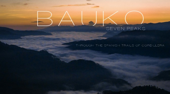
Sunrise in Bauko
We patiently waited for the sunrise while having the views all to ourselves.

As the dawn broke over the horizon, the horizon painted itself from pitch black darkness to dreamy hues of blue and purple. The sweeping 360 degree vista from the summit was definitely a sight to see.


The team could not contain their excitement as the clouds from down below started to float as if they were as thick as cotton balls. It wasn’t exactly as grand as that of in Mts. Pulag, Amuyao nor Napulauan, but it has this kind of charm that is worth seeing especially on this side of Mountain Province.


From the other side lies the famous Kiltepan Peak with the much coveted sea-of-cloud cover but take note that it looks even more stunning from this view point, trust me on this!


Everywhere I look at, the view turns into a promising vista of clouds, trees and rice terraces illuminated in the first light of the morning.


From the campsite, Sir Tatah and the others kept yelling that breakfast was served. But most of us are quite stubborn as we waited for the sun to rise.


The gift of Bagnen Oriente which is Mt. Polis, although named the same as that of the Provincial Boundary of Ifugao and Mountain Province, is a gem worth seeing.


The Spanish Trail
After having another set of sumptuous meal, everyone started to break camp to prepare for the next leg of the hike today. We started the descent on the other side of the mountain until we reached the Mountaineers Homestay. This is managed by Sir Paul Bill’s Family (our guide).

Then we just passed from here through several houses and narrow concrete pathways before the so-called Spanish Trail starts. Resuming the trek by 08:30am, the community eventually vanished as we entered the thick forest covers of the Spanish Trail.


A historic path laid now with thick bushes and flora, I kid you not, it was used by the Spaniards during the Spanish Occupation. This was used to expand their territorial reaches and also to introduce Catholicism on this side of the Cordillera Region.
Also, this trail was used by the Japanese Soldiers during the World War since the forest provides the best vantage point of the low lands. Also, a perfect cover during assaults by the Filipino Freedom Fighters.
As of today, this is now again used by the locals to connect the communities of Bauko, Tadian, Besao via Toktok Allan or Bagnen Oriente and vice versa.

There’s only one water source along the way. Limatik infested portions are after the Cotcot Aso Soil Jar (the first water source) before reaching Mt. Kapowao. The trail from here is wide enough and is semi covered in pine trees.


From the junction of Mt. Kapowao, the highest peak, Mt. Nentingle looms like a sentinel from the other side. We left our bags in the junction then did a rather quick (and exhausting) 20 minute assault to reach the very peak of it.
The trail was steep at some portion with loose rocks and soil, but from the top, the view was rewarding enough. The low lying community of Bagnen Oriente dwarfed by Mt. Polis looks like a civilization in the sky.


The descent took us almost the same time as we did in climbing Mt. Nentingle to take caution of the slippery portions. Upon arrival in Mt. Kapowao Junction, we resumed to the next peak which is Mts. Mangasil and Bato.

Almost an hour away, we passed through mountain sides with deep ravines on the side. At some parts there are raised pathways/trails for people and some trenches which I assume are for horses and cows due. Then we arrived in Mt. Mangasil, which happens to be a knoll with views of Tadian, Ilocos Sur.
From Mt. Bato, the group decided to regroup so as to discuss who will be pursuing the last two peaks of Mts. Amo 1 and 2, since the weather might get worse by late afternoon.

I decided not to continue and descend on the migratory foot path leading directly to Brgy. Bila. Five of our group members continued on despite the ominous weather that was about to break in no time.
Passing through the Pandey Rice Terraces, we reached Brgy. Bila by 02:00 in the afternoon. Heavy rain fell as it clattered relentlessly on the sari-sari store roof where we took refuge. It took us roughly seven (7) hours to almost complete the circuit but still worried with the others which just recently reached the first peak. From there it is still around two hours away from the jump-off.


We tidied up in Otucan Sur, a community around a quarter of an hour away from Bila. After we tidied up, our remaining group members arrived and made it all through the last 2 peaks after two more hours.
Take Aways
We all bid goodbye to the wonderful people who assisted us on this one of a kind hike. Undoubdtedly, we are in high hopes that this area will be finally known by many because of the number of hiking trails with amazing views, waterfalls, rice terraces and the like.

In no time, this will be more accessible to more tourists as the 18km Sagada-Bauko Road is now eyed by the local government to link Abatan, Mountain Province – Ilocos Sur Junction leading to Sagada.

If planning your next hike to the Cordilleras, you might want to consider the lesser known yet historic trails of Bauko!


