
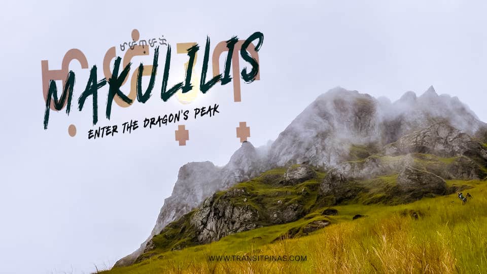
Mt. Malindig – Makulilis Peak, Marinduque | Entering The Dragon’s Peak
Mt. Malindig – Makulilis Peak (1000+)
Torrijos, Marinduque
Jump-off Point: Old GSP Building, Brgy. Dampulan, Torrijos, Marinduque
LLA; N/A: 13.227652, 122.024531, 1000-1050MASL
Days Required/ Hours to summit: 1-2 Days, 6-8hrs to peak
Specs: Major Climb, Difficulty 6/9, Trail class 1-2, grasslands, boulders, secondary forests

This is the author’s account of their Makulilis Peak attempt last July 2017. This blog includes tips, itinerary, travel guide and where to go in Marinduque after hiking.
“Kaunti na lang, malayo pa.” (Just a little bit more, it’s still far away) I jokingly told everyone else as we trudged the steep grassy slope.

The rugged crest seems like it is within an arm’s reach at our current elevation of past a thousand feet, but the top was generally around 3,300ft in elevation. Just like most of the peaks in the country, every summit looks too near yet so far.

The Road to Torrijos
The morning haze enveloped Balanacan Port in Mogpog, Marinduque as our vessel moored into one of its berths.


This port is one of the main gateways to the mainland Luzon, particularly in Lucena, Quezon.
Upon entry to the land of the famed Morions, a giant statue of the Virgin Mary, welcomes everyone setting foot in the province.

We then transferred into a Jeepney that took us to the town of Sta. Cruz. After half an hour of travel over 38 kilometers, we have finally arrived at the quaint little town.

A giant Roman warrior’s bust, a “Morion” as it is called, stood out in the plaza as we walked past it looking for a place to have our breakfast.

Across the plaza, the oldest parish church in the province, the Santa Cruz Church. The church was well preserved and stands out from the rest of the structures for its fortress like walls.

The interiors still boast of its original painted ceiling, the intact retablo and pulpits that was used by the Jesuits since 1792.

This church served not only for the purpose of religious activities but also to protect the locals during the height of the Moro Raids and natural calamities.

The Road to Dampulan
After our breakfast, we then proceeded into a 45-minute trip to Torrijos, Marinduque where the jump-off point of Makulilis Peak starts. Turning left from the Marinduque circumferential road, we entered into a coastal road that led us to Brgy. Dampulan.
The jump-off point is at the old and dilapidated Girl Scouts of the Philippines (GSP) building. Due to lack of information prior to the hike and only relied on our contact, we coordinated with the local barangay first to register. No fees are collected as of writing and guide fees start at 1000php for a day hike.

Makulilis Peak is one of the peaks of the potentially active Mt. Malindig. The mountain’s highest point stands at 1,157 meters above sea level. In addition, is accessible through the Buenavista Trail.
Albeit being highest, the summit is forested and gives you a rewarding view at the military outpost at around 900MASL.
Maculiglig
From an old Jesuit note of P. Juan de Noceda and from Vocabulario de la Lengua Tagala, from 1832, it said that the place is named Ma-culiglig. In restrospect, “Culiglig” is a tagalog term for crickets, thus Makulilis, onomatopoeic in nature.
Further checking out the description from that period, they define “culiglig” as a slang, derogatory term for rumor spreaders and gossipers. “Culiglig n. – Chicharra se dice de una mugger habladora” (Culiglig noun. – gossip girl). (www.marinduquegov.blogspot.com)

Makulilis Peak was known even before the Spanish Colonization and was described during the Chinese Trade era. Stories call this the White Peak of Mt. Lo-Huang, where on top of it is a passage to another world filled with golden palaces, carriages and elementals with supernatural powers.

The Journey to the Dragon’s Lair
From the community, the trail starts on a forested path with tree canopies. The trail was a little challenging at first, owing to the branches and vines scattered along the unestablished trail. Our guide bushwhacked every now and then since there’s hardly any mountaineers coming up from this part of Marinduque.

The air felt heavy as the morning breeze faltered and the midday heat started. After half an hour, we came out of the small forest and ensued into a wide grassy plain.

The rocky peak seemed otherworldly from where we stood. Grasses that spread around a steep slope abruptly ends into the jagged rocky outcrop. It seems like the crown of the White Walker’s Night King from the series A Game of Thrones.


The rugged crest seems like it is within an arm’s reach at our current elevation of past a thousand feet, but the top was generally around 3,300ft in elevation. Just like most of the peaks in the country, every summit looks too near yet so far.


“Kaunti na lang, malayo pa.” (Just a little bit more, it’s still far away) I jokingly told everyone else as we trudged the steep grassy slope.
Noon came and our lungs couldn’t keep up, and we were exhausted from the heat as there’s hardly any shade to rest upon. We slowly traced our steps until we reached what seems to be the dragon’s lair.


From that point, at around 900 meters, the steep trail broke sharply in what seems to be an ancient talus slope that, for the uppermost ten meters or even more, was almost a sheer cliff. There are a few boulders that we can climb onto but it seems dangerous to ascend without a rope.


The view from where we were standing afforded us a panoramic vista that encompasses Mindoro, Verde Island Passage and the nearby Elephant Island. Unfortunately, we did not pursue climbing up to the rocky peak since we don’t have any guide ropes with us.


Going down was fun, since there’s grass everywhere and only scree at some point, we slid down on our butts and screamed like children having the time of their lives.
From Poctoy to Boac
Tired from the Makulilis Peak attempt, we set up our camp at the Poctoy White Beach in Torrijos. True to its name, the sand was coarse and creamy white in color. From there, Mt. Malindig looms faintly from a distance.


The following day, we ventured towards Boac since we still had some time to spare and took notice of the ancestral houses lining up the province’s capital. This town stages one of the famous Philippine Festivals during the Lenten season, the Moriones Festival.


The town also has the massive Boac Cathedral standing on top of the hill. What makes this special is the fortress like walls surrounding the church which makes it look like you’re in a medieval setting.

Moreover, the church resembles the Paoay Church for the large buttresses supporting the structure from both sides.


Marinduque is called as the “Heart of the Philippines” for being the geodetic center of the country with the Luzon Datum in Balanacan.


How To Get There
- By air, Cebu Pacific now flies to Marinduque three (3) times a week at the following schedules:
- MNL -MRQ – flies three (3) times a week (Monday 1525/ Wednesday 0735/ Friday 0735)
- I tried to mock book a month in advance and cheapest regular roundtrip promo fare costs around 2,192.12php
- MNL -MRQ – flies three (3) times a week (Monday 1525/ Wednesday 0735/ Friday 0735)
- By land, ride a bus from Cubao or Buendia (near LRT station) en route to Lucena Grand Terminal, Lucena or Dalahican Port. (230php/pax, 3hrs travel time)
- Ride a RORO (roll-on-roll-off) or fastcraft bound to Balanacan Port in the town of Mogpog

- From Balanacan Port in Mogpog, transfer to jeeps or vans bound for Torrijos. (1 hr travel time)
- Alight at the Dampulan junction in Torrijos and charter a tricycle to bring you to the old GSP building in Brgy. Dampulan
- Please contact Councilor Ipit Palermo at 0948 286 7020 to coordinate your scheduled visit and secure your guides
<iframe src=”https://www.google.com/maps/embed?pb=!1m16!1m12!1m3!1d53160.81872710573!2d121.99441840687142!3d13.231878465399486!2m3!1f0!2f0!3f0!3m2!1i1024!2i768!4f13.1!2m1!1sbrgy%20dampulan%20makulilis!5e1!3m2!1sen!2sph!4v1594027872668!5m2!1sen!2sph” width=”600″ height=”450″ frameborder=”0″ style=”border:0;” allowfullscreen=”” aria-hidden=”false” tabindex=”0″></iframe>
Itinerary and Expenses
Day 0
2000 – Assembly at Cubao, Quezon City
2100 – Depart for Lucena (250php/each)
Day 01
0100 – Arrival at Dalahican Port, Lucena, secure tickets
0200 – Depart for Marinduque (390php/each)
0500 – Balanacan Port, Marinduque, breakfast
0600 – Depart for Torrijos, Marinduque
0730 – Brgy. Dampulan, secure guide
0900 – Start trek
1200 – Mt. Makulilis Viewpoint, (unable to summit due to lack of ropes)
1500 – Back at jump-off point
1630 – Depart for Poctoy White Beach
1700 – Poctoy White Beach, set-up camp
1900 – Dinner, socials
Day 02
0900 – Breakfast, free time
1430 – Break camp
1600 – Depart for Balanacan Port
We joined an organized event by the OHMC Mountaineers. The trip costs 2,800php inclusive of food, transportation and guide fees. You can contact Sir Carlos Joseph Felix through his Facebook Acct HERE.

Enter The Dragon’s Peak | Mt. Malindig – Makulilis Peak, Marinduque Updated July 09, 2020


