
Mt. Talamitam (630 MASL), Batangas | A Merrell PH Sunrise Mission
Mt. Talamitam is the younger sister of the imposing Mt.Batulao which is also located in Nasugbu, Batangas.
![]()
In this sunrise mission together with Team Merrell Phillippines, let us take you to the windswept peak of Mt. Talamitam!
Trail Notes
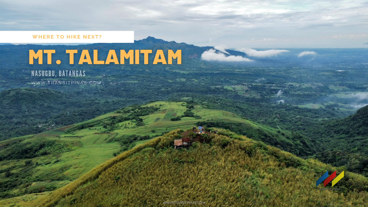
Mt. Talamitam
Nasugbu, Batangas
Jump-off point: Sitio Bayabasan, Brgy. Aga, Nasugbu (KM. 83)
LLA: 14.1158° N; 120.7577° N; 630 MASL
Days required/ Hours to summit: 1 day / 1.5-2.2 hours
Specs: Minor climb, Difficulty 3/9, Trail class 1-3 with steep assault (100m)
www.pinoymountaineer.com
![]()
Merrell PH Sunrise Mission
I was lucky enough to be invited by Merrell Philippines on this hike with new friends in Mt. Talamitam in Nasugbu, Batangas. Also, time to test the new Merrell Moab 3 waterproof hiking shoes!
Upon arrival in Sitio Bayabasan, we immediately started the hike after a quick orientation. We then passed by several houses on a now concreted road until we crossed the Layong Bilog River. From there on, we entered a now muddy trail inside a woodland with a gradual gain in elevation.
![]()
This short forested trail ascends into a gentle slope until it ensues into a wide grassland plateau. Cows and horses graze over this wide portion of the mountain.
![]()
![]()
But this could’ve been better if the sun rose on the right side of the bed. Although during this sunrise mission, it hid behind the clouds. On the brighter side, we had cloud covers throughout the hike, sparing us from the intense heat.
![]()
![]()
This plateau was said to be once abundant with Talamitam trees, hence the name. Also, a verdant ecosystem welcomes the locals entering the mountain, but they all eventually disappeared today. Moreover, efforts are said to be underway to rehabilitate the now bald mountain.
![]()
![]()
![]()
![]()
Windswept Peak
Far from the hustle and bustle of the city, the view from our resting area was quite a reprieve.
![]()
![]()
Then we continued until we reached the foot of the steep hill that leads to the summit. The almost 60-degree ascent on the cogon grassland stretches for about a hundred meters.
![]()
![]()
Albeit being muddy from the rains that visited the area this morning, my Merrell Moab 3 did a good job and I felt confident with each step I took.
Then in just a few minutes, we finally reached the summit of Mt. Talamitam (630 MASL)!
![]()
![]()
![]()
![]()
![]()
From the summit, one will be rewarded with the imposing view of the grand landscapes of the neighboring Mt. Batulao.
In addition, one will get nice views of the surrounding towns of Batangas such as Balayan, Tuy, Lian, and Calatagan and the mountains of Maragondon in Cavite.
![]()
Notable peaks include Batulao to the southeast, Mt. Makiling which is partially covered by the Tagaytay Ridge, Pico de Loro to the west, and the Lubang islands of Occidental Mindoro to the southwest.
![]()
![]()
![]()
Merrell Moab 3
In this hike, my new Merrell Moab 3 was put to the test as it took on the varying trails of Mt. Talamitam. From the muddy woodlands, the slippery rocks of Layong Bilog River, up to the steep cogon grass hill leading to the summit – the Merrell Moab 3 did not disappoint.
And to be honest, it passed with flying colors when I used it during this hike.
I have been using the Merrell Moab 2 for three years now, and it proved its grip, comfort, and durability, particularly on the granitic slopes of Mt. Kinabalu in Malaysia.
View this post on Instagram
Furthermore, with this new version, the Merrell Moab 3, seems to be the real deal. Can’t wait to use it on my next major hikes around the country!
The Merrell Moab 3 is famous for its out-of-the-box comfort, durability, and all-purpose versatility. Moreover, its predecessors have enabled 25 million people to step further outdoors.
For over a decade, the Merrell Moab has been the choice of hikers when a choice needs to be made, making it the best-selling hiker in the world.
Moab 3 Key Features
- Pigskin leather and mesh upper
- Bellows tongue keeps out debris
- Protective toe cap
- Kinetic Fit TM ADVANCED removable contoured insole with reinforced heel cushioning for medium support
- Molded nylon arch shank
- Lightweight EVA foam midsole for stability and comfort
- Lug depth 5.0mm
How to Get There
- Mt. Talamitam is located in Nasugbu, Batangas, with its main jump-off point in Sitio Bayabasan, Brgy. Aga. Also, an alternate jump-off point at Brgy. Kayrilaw is also available
- From Manila, take any Nasugbu bound bus in Edsa Taft or in Buendia, Pasay City (Travel time: 3-4hrs, 85.3 kilometers)
- Ask to be dropped off at Bayabasan Elementary School, then from there charter a tricycle going to the jump-off point of Mt. Talamitam
- Trek time is around 1.5-3hrs depending on your pacing
![]()
- The trail length is 3.5 kilometers from the highway to the summit with an elevation gain of 436 meters
- This is an easy hike that is recommended for beginners
- Furthermore, the way is fairly straightforward, while the assault gets steeper only when nearing the summit
- Check the weather before the hike. Tree cover is only present at the start of the hike and will be exposed grasslands from thereon to the summit
- Rates and fees as of May 2022:
- Guide Fee: 500php : 5 pax
- Tourism Ecological Fee: 20php
- Barangay Donation: 20php
- Shower Fee: 20php
- Signal and data reception for all networks is available from the grassland up to the summit
- Camping is not allowed at the summit. The designated campsite is in the grassland area near the sari-sari store
- If you are up to the challenge you can couple this with Mt. Lantik and Mt. Apayang – they are both an hour away from the summit of Mt. Talamitam
- Water Source is available in the grassland, but several stores in the resting areas are also available. During the weekend, there are makeshift stores selling snacks and refreshments at the very summit
- Follow LNT Principles at all times
Itinerary and Expenses
0400 ETD DLTB bus terminal, Buendia to Nasugbu, Batangas
0700 ETA Registration area at Sitio Bayabasan, Brgy. Aga (KM. 83)
0730 Start trek
0930 Arrival at the summit
1030 Start descent
1200 Back at the registration area, head to Tagaytay or Manila
1300 Lunch at Tagaytay
1430 Head back to Manila
1700 ETA Manila

 Updated June 02, 2022


Pingback: Taal Basilica, Batangas | Asia’s Largest Roman Catholic Church
Pingback: Taal Heritage Town, Batangas | Through the Looking Glass