
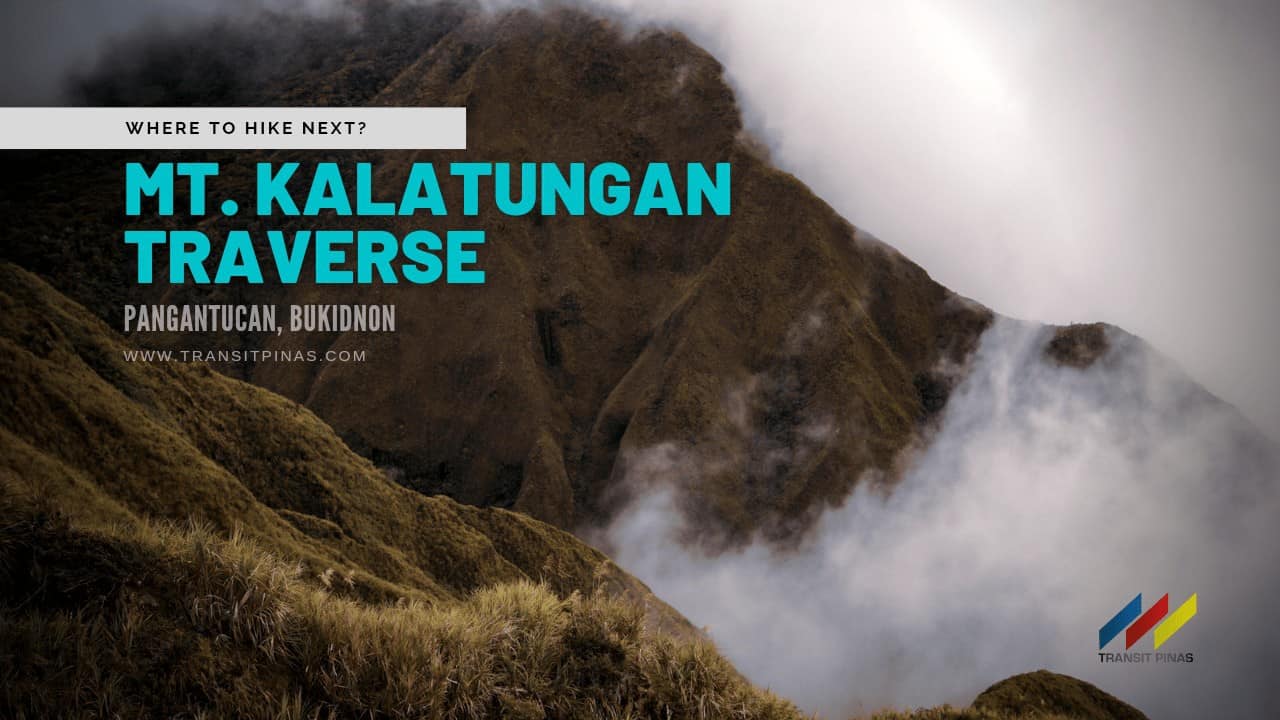
Mt. Kalatungan Traverse| A Daring Climb Into the Kalumbata’s Territory
(Updated as of May 25, 2023)
The Kalatungan Mountain Range complements the equally alluring Kitanglad Range in the southwest. This is perhaps one of the most challenging climbs we’ve done in a while and I can’t wait to try it again!

In this Kalatungan Travel Guide, let us take you to the 5th highest mountain in the Philippines. So here goes nothing!

Kalatungan Reopens!
As of May 15, 2023, Pangantucan Tourism announced the reopening of Mt. Kalatungan Range Natural Park on June 09, 2023.

MT. KALATUNGAN TRAVERSE VIA MAKAUPAO PEAK
Talakag and Pangantucan, Bukidnon
Entry point: Brgy. Miarayon, Talakag
Exit point: Brgy. Mendis, Pangantucan
LLA: 7°57’18″N 124°48’09″E 2880 MASL (#5)
Days required / Hours to summit: 3-4 days / 15 hours
Specs: Major climb, Difficulty 8/9, Trail class 3-4
Features: Tribal domain, mossy forest, Top 10
(www.pinoymountaineer.com)
**Our group took the traditional route of Brgy. Mendis – Kalatungan – Lumpanag/Wiji/Makaupao – Brgy. Mendis Trail

After a long and tiring travel from Davao City going to Pangantucan, we settled in for the day at the hut just adjacent to the ritual area of Brgy. Mendis.


The Pangapug Ritual and the Igmale’ng’en
The Manobo or Menuvu Tribe on this side of Mt. Kalatungan has and will always be the traditional stewards of the revered mountain’s resources. In fact, Manobos and Talaandigs believe that the Kalatungan Range including the “Igmale’ng’en” or sacred forests are home to the tallest and hardest trees.

Moreover, it is where the cleanest waters will always flow and never runs dry, where the boars and deer will roam and the “Kalumbata” or the Philippine Eagle will fly free. (De Vera and Guina, 2008)

In addition, the Igmale’ng’en represent everything that is pure and strong, and the conservation of it ensures the tribe’s continued existence and survival. Thus, any mountaineer wishing to climb must first coordinate with the Tribal Council through Pangantucan Tourism Office or with the help of Dauntless Outdoors.

As is the custom of tribal communities, a ritual called “Pangapug/Panlugbak” was performed by the Datu on our arrival before the start of the climb. A live chicken was offered to appease the spirits to ensure that we will find favor with the deities of the mountain.

First part is where the chicken’s blood was offered so the spirits may not ask for any of our blood during the climb. Also, Datu Erio D. Inahan or Datu Solotan Karatung Intoyadeg of the Kalatungan Mandum Tribal Community offered coins, liquor, soda, strips of red and white cloth and our ID pictures before the climb.

A few moments later, the chicken was cooked and we were asked to eat it ‘together’ with the forest spirits in some sort of breaking bread custom.

As provided by “Megbeveya”, local name for God, any form of transgression will equate a penalty as defined by the tribal justice court, “Denempasan”. Thus, the act of “Pag-sasala”, or in which one will be tried in court.

The Flight of the Kalumbata
At around 02:30 in the morning we started the hike along the slopes of Mt. Kalatungan under the canopy of a billion stars.

Passing by mostly open grasslands and a bamboo bridge over one of the subsidiaries of Kalatungan River, we reached the 2-storey wooden view deck after two hours (1607 MASL).

To prevent our bodies from cooling down, we continued on until we entered the tree line until our group reached the first rest area. The warm morning light started to break from the horizon, giving life to the forest we were treading on.


Four hours into the climb, we then set foot in Kikikoka Peak at around 1907 MASL where we had our breakfast. Realizing there’s still a thousand meters to climb, we steadied our hearts and continued on with the climb.


As the sun started to illuminate the vast forests of Mt. Kalatungan we came out of the woods as we approached Buko-Buko sa Anay. Then the unexpected happened; two large birds were circling on top of the ridge.

Moreover, their wing spans are large and rounded to be that of the Brahminy Kites or “Lawin” in Tagalog. Consequently, our guide told us that it was no other than a pair of juvenile Philippine Eagle (S.N. Pithecophaga jefferyi). The Kalumbata’s definitely gave us a warm welcome into their humble yet vast abode.

The Rainbow Waterfall: Muleta Falls
It was either sunrise or sunburn going to Muleta; we chose the latter because we were as slow as sloths. Climbing the open and steep ridge of Buko-Buko sa Anay (2003 MASL) was no ordinary feat. As the sun started to gain traction up in the skies, so does the heat it gave away.

Five hours into the climb, we gained a thousand meters of elevation already. Our legs started to feel the fatigue but it all went away as we arrived at the Muleta Falls Viewdeck (2184 MASL).![]()


At this point, a towering waterfall, said to be more than a hundred meters high spews out from in between the mighty peaks of Kalatungan and Wiji. The morning light casted interesting rainbow colors on the cascade that morning, what a sight!
![]()
![]()
Muleta Falls is said to be only accessed by their “Baylans” and ancestors that up to this day, no one dared to venture out into its catch basin. In addition, it is said to be part of the sacred forests of the IPs.


Heat started to catch up unto us as we slowly treaded our way to the tree line past Buko-Buko sa Anay.


Eight hours have passed before we arrived at Sako Camp (2497MASL), where we hurled our bodies down to the ground to catch a quick nap.

Kalatungan’s Daring Assault
The forest from here started to warp on its own as the temperature steadily dropped. Trees started to wear their evergreen moss jackets while their gnarly branches seemed to reach out to the sky. Trailing vines, orchids and tree roots are in complete disarray – one might get lost easily in its beauty.


Mt. Kalatungan was no easy climb as our lungs gave away after a few meters of hiking while carrying our heavy backpacks. Nine hours in, the mossy forest started to become as enchanting as that of Mt. Dulang-Dulang (Check our climb HERE).


We then had our lunch at the Junction of Sanggaya and Kalatungan at 2730 MASL. After a well deserved meal, we left our bags and started to close the gap from where we were standing up to where the 5th highest mountain peak in the country stands.

At exactly 02:00 in the afternoon, almost 12 hours into the climb, we finally arrived at the summit of Mt. Kalatungan (2907 MASL)!


It was no easy climb, albeit having no view from up there, the fulfillment and the price we had to pay just to reach this two-thousander of a mountain will definitely have a special place in our repository of memories. WUHOOO!

The Bamboo Camp and the Search for the Missing Bamboo
By 03:00 in the afternoon, rain started to pour mercilessly down upon us. The forest while going down to Sanggaya/Bamboo Camp (2547 MASL) was out of this realm, too bad we had to descend quickly or risk getting hypothermia from the incessant downpour.

Half an hour from the junction we arrived at the camp where we will spend the night. The almost unforgiving rain was partnered by the frosty mountain air. We immediately took refuge inside our tents and braced for the incoming temperature drop. As Ned Stark once said: “Winter is Coming”.

After having dinner, we cocooned ourselves inside our sleeping bags, but our efforts were futile as the cold caught up unto us as the long night went on.


Originally, we were planning to start our second day at 04:00 in the morning, but it was like a freezer outside that everyone crawled out of their tents past 05:00am. Coffee definitely saved us while waiting for breakfast.


The mossy forest here was even more enchanting, but definitely no Bamboos to be seen albeit being called as the Bamboo Camp.
Lumpanag: Drop Dead Gorgeous
Ascending Mt. Lumpanag/Wiji was another story. From the Bamboo Camp it seems top be so near, but the climb was taxing as we got closer and closer to the peak. Just like the previous day, the trail got steeper by the second, and you just got no choice but to fight this uphill battle head-on.

The neighboring Kitanglad Mountain Range is now seen from here. Dead Trees are scattered along the trail together with unique flora and wild berries.


After half an hour from the camp site, the trees started to disappear and only grasslands prevailed as we arrived at the summit of Mt. Lumpanag/ Wiji (2819 MASL).


The view from here was stunning as the clouds started to float around the vast plains of Bukidnon. The towering peaks of Mts. Apo, Ragang and Matutum to name few flanked the horizon.


Although being a hundred meters short of that of Mt. Kalatungan, it never got short of what it can offer. One might drop dead just by trying to scale it, but it is as gorgeous as any mountain peak on a beautiful weekend morning.


Lumpanag/Wiji’s grasslands are wide and distinct with dead tree branches from a previous fire incident. We were exposed to the elements, the breeze was freezing, but the view up there was exceptionally glorious.


Protected Area: A Boon and A Bane
Mt. Kalatungan Range Natural Park (MKaRNP) was declared a protected area under the NIPAS Act in May 2000. Moreover, the park is home to 429 species of endangered and/or endemic flora and fauna such as the Philippine Eagle, Philippine Deer and Philippine Wild Pig, mountain rodents as well as 109 species of mosses.

But up top this day, this cloak of protection is still not enough as rampant deforestation, and conversion to agricultural lands, wildlife poaching and abuse of the mountain is still prevailing.

For the Manobo and the Talaandig, being the sole stewards of the mountain since time immemorial; the use of the resources has always been governed by their beliefs, traditions, and intense familiarity of the mountain range. But sad to say, it is still a downhill battle against the transgressions of humans until now.

As a mountaineer and a visitor to their ancestral domains, respect should be paramount at all times. Follow LNT principles and let us be one of their helping hands in safeguarding this valuable yet vulnerable ecosystem by raising awareness on how important it is for everyone.

Dead Nail’s Trail
The descent was as taxing as the ascent. Still a long way to go, but the danger zones were unparalleled in terms of the views it offered.


Then it was a gradual trek going down, but it might take a toll on your knees and toenails. In fact, the descent trail is infamously called as the Dead Nail’s Trail.

A few slips here and there until we reached Lisihun Creek (2430MASL) after two and a half hours from Mt. Lumpanag/Wiji to refill our water bottles.


It took us six hours from the Bamboo Camp down to Brgy, Mendis as we bid goodbye to the 5th highest mountain in the country.
Travel Tips
- Mt. Kalatungan Range Natural Park is located in Bukidnon with its main jump-off at Brgy. Menis in Pangantucan
- This is not an easy climb and is rated with an 8/9 difficulty. Prepare accordingly
- Respect and follow local traditions

- Check local health requirements and travel restrictions before the climb:
- Our flight is from Manila to Davao. As of writing, Davao City requires tourists to present the following:
- Vaccination Card
- Negative RT-PCR Result taken 72 hours or Saliva RT-PCR taken 48 hours before the flight
- Safe Davao QR Code
- Valid ID
- Log-in at the Military Detachment of Brgy. Mendis before proceeding to the ritual hut
- Our flight is from Manila to Davao. As of writing, Davao City requires tourists to present the following:

-
- If coming from Cagayan De Oro:
- From Cagayan De Oro, take any bus bound for Agora Market, then transfer to buses or vans bound for Maramag, Bukidnon (145 kilometers via Sayre Highway).
- Upon arrival in Maramag, transfer to buses passing through Poblacion in Pangantucan, Bukidnon (25 kilometers via Bukidnon-Wao Road)
- In Pangantucan, contact your guide for habal-habal or motorella going to Brgy. Mendis
- If coming from Cagayan De Oro:
-
- If coming from Davao City
- From Davao City Overland Bus Terminal, take any bus bound for Maramag, Bukidnon (152 kilometers via Davao-Buda National Highway).
- Upon arrival in Maramag, transfer to buses passing through Poblacion in Pangantucan, Bukidnon (25 kilometers via Bukidnon-Wao Road)
- In Pangantucan, contact your guide for habal-habal or motorella going to Brgy. Mendis
- If coming from Davao City
- For a faster and more all-in organized climb:
- From Mindanao, you may contact Ms. Liz Tiongson of Dauntless Outdoors through their Facebook page or call 0945 738 4632 for faster transaction
- From Luzon, you may contact Jaime Dequinon of Akyat Tanaw Mountaineers through their Facebook page
- Trail Length:
- Total Length Mt. Kalatungan Traverse Mt. Wiji: 18.389km
- Mendis to Viewdeck – 3.6km
- Viewdeck to Kikikoka Peak – 1.21km
- Kikikoka Peak to Buko-Buko – 0.71km
- Buko-Buko to Sako Camp – 2.13km
- Sako Camp to Junction KP and BC – 0.72km
- Junction KP and BC to Kal Peak – 0.51km
- Junction KP and BC to Bamboo Camp – 0.99km
- Bamboo Camp to Mt. Wiji – 0.81km
- Wiji to Crossing Bagong Buhay Mandum – 1.11km
- Crossing Bagong Buhay Mandum to Lisihun Creek – 0.62km
- Lisihun Creek to So. Mahayahay – 3.97km
- Mahayahay to Brgy. Mendis – 2.03km

- Enjoy what the mountain can offer. Always follow LNT Principles
- Signal and data connection are intermittent but available at the Muleta Falls Viewdeck and Mt. Lumpanag/Wiji only for Smart subscribers
Itinerary and Expenses
Mt. Kalatungan Traverse 2D1N

Day 01
1500 Flight from Manila to Davao
1700 Arrival in Davao, clearance and submission of health requirements before entry
1900 Check-in at Davao, Dinner
Day02
0630 Depart for Pangantucan, Bukidnon
1030 Arrival at Maramag, Bukidnon, buy supplies, brunch
1200 La Montana, Pangantucan, Bukidnon orientation by Dauntless Outdoors
1340 Arrival at Brgy. Mendis log at the Military Detachment
1730 Ritual
1830 Dinner
2000 Lights Off
Day 03
0230 Start Hike
0320 River Crossing 1300 MASL
0420 Viewdeck 1607 MASL **
0515 Rest Area 1727 MASL
0630 Kikikoka Peak 1907 MASL
0720 Start of Buko-Buko sa Anay, 2003 MASL
0750 Muleta Falls Viewdeck 2184 MASL
0900 Resume
0935 Rest Area 2322 MASL
1030 Sako Camp 2497 MASL
1145 Junction Sanggaya Camp-Kalatungan Summit 2730 MASL, Lunch **
1315 Start final assault to Mt. Kalatungan Summit
1400 Mt. Kalatungan Summit 2907 MASL
1430 Start descent
1500 Junction
1530 Sanggaya/ Bamboo Camp 2547 MASL, Set-up Camp **
1830 Dinner, Socials
2000 Lights Off
Day 04
0400 Wake-up call
0620 Start ascent to Mt. Lumpanag/ Wiji
0705 Mt. Lumapanag/Wiji Summit 2819 MASL
0830 Start descent via Dead Nail’s Trail
0840 Danger Zone/ Cliff Area
0900 Junction Mendis-Lake Napalit 2560 MASL
0925 Lisihun Creek **
1010 Rest Area 1 2280 MASL
1140 Sitio Mahayahay
1315 Brgy. Mendis, Wash-up
1730 Depart for Poblacion, Pangantucan
1815 Awarding of Certificates
2030 Dinner at Maramag, Bukidnon
2345 Arrival at Davao
Day 05
1400 Flight back to Manila
1600 Arrival in Manila
NOTE:
** Water Source
*** Event fee was priced at 7000php all-in expenses from Davao-Bukidnon and vice versa (excluding airfare and RT-PCR Test)
**** Event was organized from Manila by Jaime Dequinon of Akyat Tanaw Mountaineers and then coordinated with Ms. Liz Tiongson of Dauntless Outdoors
***** Follow minimum health and safety protocols, Davao and CDO as of writing require RT-PCR (taken 72hrs) and Saliva Test (taken 48hrs) before the flight and will be presented upon arrival
Where to Stay
- Hotel Valencia, Valencia (Bukidnon), Philippines

- GV Hotel Valencia, Valencia (Bukidnon), Philippines

- Double M Hotel, Valencia (Bukidnon), Philippines

- Casas del Salvador, Valencia (Bukidnon), Philippines

- Hotel de Susana and Resort, Valencia (Bukidnon), Philippines


 Updated November 08, 2021
