
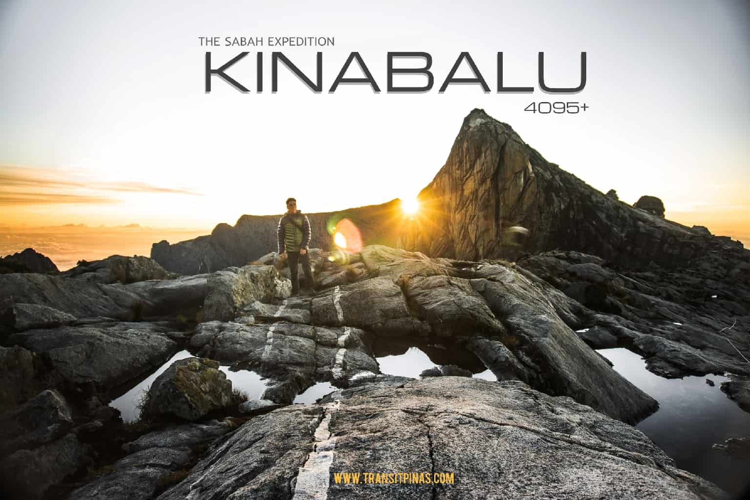
The Sabah Expedition – Mt. Kinabalu 4,095+ (Part I)
Mt Kinabalu is the highest peak in Malaysia we’ve all been dreaming of climbing, the time for us has finally come.

And after an hour from the Villosa Shelter, we have finally arrived at Mt. Kinabalu’s Panalaban Substation (3,272 meters) by 04:00pm. We have completed the first target of the day, which is to reach the 6 kilometer trail from Timpohon Gate to Laban Rata.

**This is the first part of the author’s account of their 2D1N climb to Mt. Kinabalu in Ranau, Malaysia last March 2020 days before the nationwide quarantine in the Philippines took effect.
Bahagian Pertama: Perjalanan ke Panalaban Substation
Part One: The Trek to Panalaban Substation
Timpohon Gate
After spending the night at Poring Hot Springs in the district of Ranau, we were then picked up at around 07:30 am by our service. The ride took around 40 minutes going back to Kinabalu Park Headquarters. Then by 09:15 am we arrived back at the HQ to secure our permit, identification cards, packed lunch and our guide.

From the HQ we boarded another van that brought us at the one of the jump-off points to Mt. Kinabalu, the Timpohon Gate. This is situated at 1,866.4 meters (6,122 ft), some 5.5kms from the HQ. The other trail, the Mesilau Gate is slightly higher at 1,933 meters but the trail was damaged by the June 2015 earthquake.


Usually, the park allows climbers to start their first day of trek to Laban Rata at around 08:00 am. Upon arrival, we were briefed by our guide as to what to expect during the first six (6) kilometers of the trek going to Panalaban Substation.

We presented our IDs at the Timpohon Gate before starting the ascent at exactly 10:00 am. We went down on a few flights of stairs on a gravel and sand track. This trail leads to the lower montane forests of Mt. Kinabalu which then leads to a small gully connecting to the main flank of the mountain. From there, we passed by the trickling Carson Falls (named after the first park warden) before eventually leading to the infinite stair cases.

Pondok Kandis
The trail after the falls rises steadily on uneven steps of stairs. Then this trail will be composed of seven (7) resting huts almost every 500 meters, called Pondoks in Bahasa Malaysia. These huts/ shelters are resting areas equipped with toilets with running water. There are also water sources in here but is untreated mountain water.

At around 1,981 meters (6,499 ft), Pondok Kandis came into view. It took us half an hour before we stopped by to catch our breath. It is also important to ascend very slowly to avoid altitude sickness. The path is steep but not too tricky, never-the-less it takes a while for lungs and feet to agree on an acceptable pace.


Pondok Ubah
The trail continuously ascends along wooden planks and stairs before we arrived at Pondok Ubah at around 10:52 am, 30 minutes away from Pondok Kandis. Situated at 2095 meters (6872 ft), this shelter is known for a very unique pitcher plant specie called the N. macrovulgaris, endemic to the Borneo. We did not noticed this specie along the trail.


Pondok Lowii
From Pondok Ubah, the trail continues gradually going up right contouring around the ridge. Species of ferns flock all the sides of the trail accompanied by trees covered in moss, lichens (Usnea spp.), liverworts and all sorts of tropical plants. This zone is the start of the cloud montane forests of Mt. Kinabalu, where trees start to become stunted, and moss starts to carpet the ground.


Then another 30 minutes from the previous hut, we arrived at Pondok Lowii situated at 2286 meters (7,498 ft) at exactly 11:25 am. This is named after a unique parasitic flowering plant called the Rhizanthes Lowii. At this point, thick mists and fog swirls and drifts with the wind.

We also noticed a small bunch of another Nepenthes species called as N. tentaculata. Which has hairy appendages running along the body of the pitcher, looking like tentacles. With the air becoming thinner, walking fast makes us breathless even more faster.
Pondok Mempening
Continuing the summit at the right side of the trail, the trees become more and more stunted as it is festooned by small orchids, fronds of ferns and some rhododendrons. I started to sweat like crazy and catch my breath a lot more after several steps, albeit the drop in temperature at our current altitude due to the steepness of the trail.

12:35pm, we have arrived at Pondok Mempening. Which took us around almost an hour from Pondok Lowii. The shelter is now around 2,518 meters (8260ft). At this point, we noticed cloud rats, birds and squirrels scampering around unafraid looking for discarded food from hikers.

Layang-Layang Station
By 01:35 pm, we have arrived at what looks like a resting camp called the Layang-Layang Station. Situated at 2,702 meters (8863 ft), this shelter has three resting areas where we took a break. We also saw climbers descending from Laban Rata and ascending Porters ferrying large and heavy loads on their backs.

Past the station, the trail emerges into a gnarly looking cloud forests growing on ultramafic soils. These soils are low in phosphates and high metals that are toxic to many plants so the species that do grow here look stunted and deformed.

Colored orange to cinnamon, from the soil to rocks, the trail looks like the yellow brick road from the Wizard of Oz. There’s a unique pitcher plant that I have been waiting to see, and at long last, I finally saw it in real life.


The Nepenthes Villosa is an ultra-highlander type of pitcher plant. With the opening of the pitcher adorned with an intricate and colorful peristome which looks like several sets of fangs. They are particularly easy to spot along the trail.


Pondok Villosa
Along the way, the trail connects with the other trail from the Mesilau Gate. This Mesilau trail is famous for the carnivorous Nepenthes Rajah, which is said to be one of the largest of its species by volume. They are giant urn-shaped traps which can contain around 4 liters of liquid, some have 2.5 liters of digestive fluids with small mammals found inside.

But while the boulders change color they don’t get any easier and the last stretch of the day’s climb is aggravated by the thinning air, we got past the fog and gave a view of the clouds gathered below the mountain.


We finally arrived at Pondok Villosa, named after the endemic pitcher plant only found in the area. This is situated at around 2,960 meters (9,709 ft) on top of a rocky patch with the forest becoming more stunted.


One of the colorful plants I noticed along the area is the Schima Brevifolia, an evergreen tree with these berry like fruits and cup like flowers.

Panalaban Substation
From Pondok Villosa, the ultramafic soiled trail suddenly changed back to the forested trail with tall trees in between boulders. We passed by the Pondok Paka at 3,080 meters (10,103 ft), named after the Paka Cave nearby.

The hike is now more aggravated by the thinner air and the more we pushed ourselves, the harder it is to breath.

And after an hour from the Villosa Shelter, we have finally arrived at the Panalaban Substation (3,272 meters) by 04:00pm. We have completed the first target of the day, which is to reach the 6 kilometer trail from Timpohon Gate to Laban Rata.


The helipad area in Laban Rata offers you a great view of the clouds from down below. We spent some time here marveling at the grand vista. The six hour trek going here was definitely worth it, plus the granite summit looks really near from here.


We booked our accommodation at Laban Rata Resthouse, one of the four mountain lodges you can stay for the night before the summit assault the following morning.


This is more like the highest hotel in Malaysia rather than a lodge. Laban Rata is equipped with electricity, running water, showers, toilets, a restaurant, heated dormitories as well as comfortable beds with pillows and blankets.
To be continued:
The Sabah Expedition – Gunung Kinabalu (Part 2)
Gunung Kinabalu Travel Guide 2020
For more information on the flora we observed in Mt. Kinabalu, you can visit this link: phylodiversity.net
Planning to climb Mt. Kinabalu? Ask us anything in the comments section below!
The Sabah Expedition – Gunung Kinabalu (Part I)

Updated March 16, 2020


