
Mt. Lakay (1,390+) – Nueva Ecija’s Rafflesia Mountain
Mt. Lakay in Nueva Ecija is a formidable peak that lies at the outer fringes of Carranglan bordering Pangasinan and Nueva Vizcaya. The summit has a makeshift view deck that takes you above the thick forest canopy.


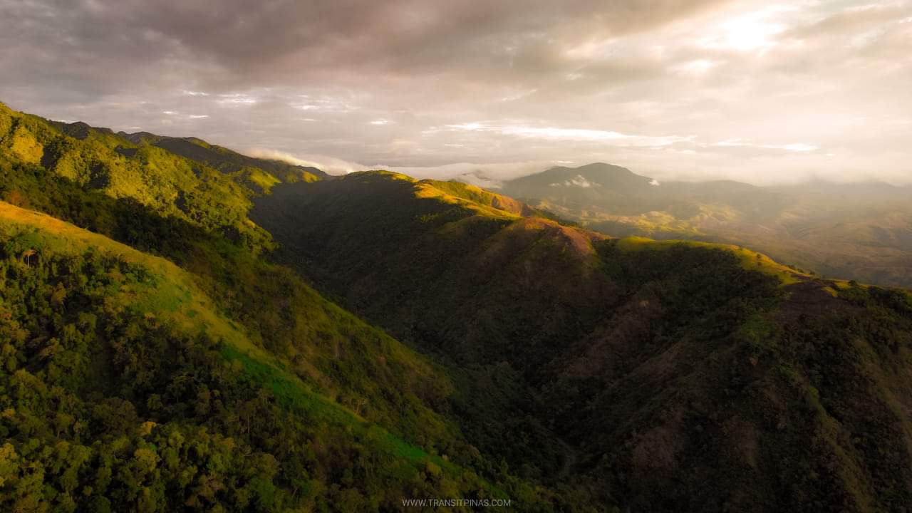
This vantage point gives you a panoramic view of the nearby provinces. We watched as the immense afternoon clouds hover above the plains of Pangasinan from a distance while the great mountain ranges of Zambales flanked the western portion.
Mt. Lakay
Carranglan, Nueva Ecija
Jumpoff: Sitio, Curva, Brgy. Puncan, Carranglan
LLA: 1,390 MASL
Days required / Hours to summit: 2 days / 6-8 hours
Specs: Major, Difficulty 7/9, Trail class 1-3

Mantalango Sunrise
“We’re here” our coordinator beckoned us to come out of the van as we abruptly stopped in the middle of a dark highway. The hike started without any further ado. It’s going to be a long day and I even have no idea what I would be seeing on top, but what the heck.

Millions of stars sprawled the night sky when we then started our trek. We passed first through rice fields before crossing several streams of the Kabulinawan River. We filled our bottles at the last water source along the Mantalango River at Km. 4.5 before starting the assault.

We treaded slowly on a steep upward slope of Mantalango trail akin that of Mt. Balingkilat’s high gradient ascent. The trail, composed mainly of grassland portions on loose soil, made the hike even more taxing. Around 3.5hrs on our climb, we decided to wait for the sunrise at the last view deck at an elevation of 780 meters at Km. 6.5


How about an awesome sunrise first?


From where we were standing, clutching a cup of coffee on the other hand, the sun started to rise from the Sierra Madre. The warm morning light – whose deep oranges and yellows dance over the landscape’s troughs and ridges.


The Hunt for the Elusive Rafflesia
The grassland ridge with bamboo thickets was abruptly cut by a dense forest. Temperature started to dip as we waded through the convoluted and primitive woods.


It was yet again, another strange world in there. We could barely hear noises aside from our heavy breathing and twigs snapping. Another hour passed before we reached a small campsite where we could refill our hydration packs.


A small pathway opened up on the left side of the camp that goes all the way to the summit. The trail went upwards then descended downwards losing around 100 meters of elevation.


We entered a dried riverbed ensued before reaching a narrow ridge where the elusive Rafflesia can still be found. And at long last! There it is..


The parasitic flower that enticed me to climb again in Nueva Ecija is the Rafflesia manillana. We found decaying flowers of which in Mt. Kemalugong in Laur last 2017. This time around I was hoping to find it in full bloom, but then again only the dried ones remained. Sigh.

It is also in this area is where the smallest of the world’s biggest bloom can be found, Rafflesia consueloae. This critically endangered flower is endemic only in Mt. Balokbok and Mt. Pantaburon inside the Pantanbangan-Carranglan Watershed in Nueva Ecija.

There are 17 Rafflesia species throughout Southeast Asia, 11 of which are found in the Philippines. How lucky of us here in Luzon to have 4, which are all endemic here.

NE’s Hidden Mountain
Then as we approached Km 11.1, the summit was within our reach. From the thick aggregate of tree crowns, a makeshift ladder cuts through them that brought us up into a viewing platform. As I clambered my way up, the view from down below was as good as it gets.


The vast plains of Pangasinan sprawled from down below as this hidden mountain lords over it. We took a moment to take everything in as our eyes got filled with this massive panorama.


We spent more than an hour on top before we descended back along Igpit Trail. We also stopped by Igpit Peak before going further down back into Kabulinawan River.


With Nueva Ecija’s new tourism hashtag #NuevaEcijaNeverEnding, the Mt. Lakay trail surely felt like it was never ending, but as they say – all’s well that ends well.

How to Get There
- Mt. Lakay is located in Nueva Ecija at the town of Carranglan, this formidable mountain rises at around 1,390 meters above sea level overshadowing its smaller neighbor, Mt. 387

- The jump-off point is at the highway of Sitio Curva, Brgy. Puncan which is 200 kms from Manila
- From the highway you will be passing along rice fields and several river crossings before reaching the foot of Mt. Lakay
- The trail leading to the summit stretches at around 11.1 kms. Our team completed the first attempt to day hike Mt. Lakay via Mantalango – Igpit Trail with the following details via the Strava app:
- Max Elevation: 1,275 meters
- Cumulative Elevation Gain: 1,437 meters
- Trail Length: 22.75 kilometers

Travel Tips
- How to Register?
- As of February 2020, Mt. Lakay is still closed to the public due to the pandemic. Some mountaineering groups are allowed to climb the mountain while following the health protocols.
- You can contact Froilan Vega of Bundokerong Pandak for more details and climb schedules. click the link HERE.
- As of February 2020, Mt. Lakay is still closed to the public due to the pandemic. Some mountaineering groups are allowed to climb the mountain while following the health protocols.

- Are Medical Certificates required?
- YES. Medical certificates from your Rural Health Unit or Barangay stating that you don’t have any COVID-19 symptoms are required
- Watersource? Campsites?
- There is only one water source at the campsite, 2kms away from the summit.
- The summit has limited space for camping and can only accommodate around 4-5 tents, no water source here

- Is it cold in Mt. Lakay?
- Yes, once you enter the forest at around 1000 meters above sea level, temperature starts to dip, specially during the Amihan season during the months of January to early March

- Limatik? Rattan?
- Limatik – none
- Rattan and other thorny plants and bushes – YES
Itinerary and Expenses
Mt. Lakay (Mantalango-Igpit Trail Day Hike)
Day 0
2100 Depart from Manila
Day 01
0200 – Arrival at Carranglan, Nueva Ecija highway jump-off point
0230 – Start trek (280+)
0250 – Kabulinawan River Crossing
0330 – Resume via Mantalango River Crossing
0400 – End of River Crossing, watersource
0410 – Resume, start of assault for Mantalango View Deck
0520 – Mantalango View Deck (780+), wait for sunrise
0720 – Resume ascent
0845 – Campsite (920+)
0915 – Rafflesia area (1020+)
1030 – Summit Mt. Lakay (1,390+)
1300 – Start descent
1340 – Back at campsite (920+), rest
1415 – Resume descent
1500 – Igpit Peak (855+)
1520 – Resume via sunflower grassland
1600 – Kabulinawan River Crossing
1830 – Jump-off point, dinner
2030 – Travel back to Manila
2330 – Manila
**Transit Pinas joined an organized tour of Bundokerong Pandak from Manila for 1800php including food, registration fees, transportation, guide fee. This excludes the mandatory medical certificate.


Thank you for visiting mt lakay.
Where i explore for the local of Sitio Curva.
Thank you, Sir Alvin! Saw your posts of Mt. Lakay and other peaks you’ve been into in the area, will wait for more of your adventures once this pandemic ends. Keep safe!