
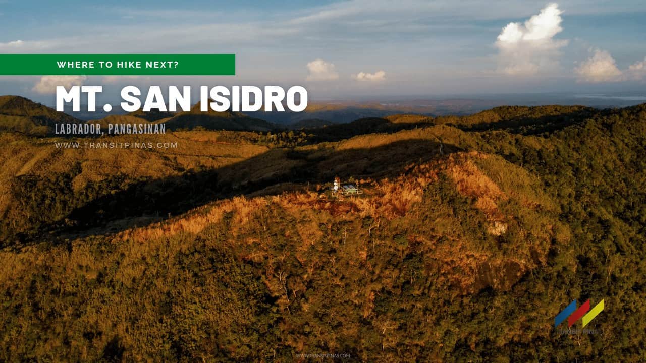
Mt. San Isidro (770+) | Labrador, Pangasinan’s Highest Peak
Mt. San Isidro is the highest point in Pangasinan and is located in the municipality of Labrador. Come and join me in this night trek to catch the Milky Way on this side of Pangasinan!

![]()
![]()
Mt. San Isidro
Labrador, Pangasinan
Jump-off point: Brgy. Kadampat, Labrador, Pangasinan
Alternate jumpoff: Brgy. Gueset, Bugallon, Pangasinan
LLA: 770 MASL
Days required / Hours to summit: 1-2 days / 4-6 hours
Specs: Minor climb, Difficulty 3/9, Trail class 1-2
Features: Scenic views of Pangasinan and Lingayen Gulf
Last updated: April 22, 2022

Sawa-deekap!
We started our trek at Kadampat Elementary School since we failed to ask our tricycle driver to bring us directly to Daling-Daling Campsite which is still around 1.2kms away. From the elementary school, we turned right going to Daling-Daling Campsite and continued for about 15mins before arriving at the fork of the campsite.


Under the blanket of a million stars, the trail was mostly rocky and ascends very gradually on an open road. Four kilometers on the same road that is reminiscent of Mt. Tapulao’s trail, we arrived at the first campsite which is a hut with a supposedly available water source. But with the pitch-black darkness around us, the area felt creepy, partnering it with the eerie silence of the forest that we just continued.
![]()
The trees on this part of the trail started to cover the road and are still the same dirt road from before with some occasional concrete segments. For two hours, the trail rewarded us with the view of Lingayen, Dagupan, Lingayen Gulf, and the roads leading to the brightly lit Baguio City.
![]()
![]()
![]()
Then as I was slowly treading along the dirt road, I jumped and scurried back as I almost stepped on a 1.5 meter long Reticulated Python. It was crossing the trail slowly so we waited for it to retreat to the other side before resuming. Sawa-deekap, hikers!

NGCP Relay Station
A final assault on a steep concreted path that made my lungs work extra harder, and voila, we arrived at the peak of Mt. San Isidro (770+)! The summit’s landmark is the steel towers on top.
![]()
![]()
![]()
The old Digitel Communication Towers were already dismantled and were replaced by smaller steel towers of Pangasinan’s Provincial Disaster and Risk Reduction Management Office. It took us 3 hours to reach this and I think it will take hikers longer if they started hiking in the morning since the sun’s heat will be more unbearable along the open trail.
![]()
One can set up camp here but it is advisable to camp near the NGCP Relay Station, which is at the lower slopes of Mt. San Isidro since it affords a better view of the lowlands. Moreover, there’s a water source in the area!
![]()
![]()
From the tower area, we descended a steep concreted path again then a small clearing with Pine Trees will welcome you. It took us around twenty minutes before we reached the hut at the back of the relay station. It is better to ask permission first from the security guard in the area since they prohibit large groups from occupying the campsite next to them.
![]()
![]()
![]()
Billion Star Accommodation
The hut offers a panoramic view of the major cities of Pangasinan and the Lingayen Gulf. But what made the hike more interesting is the Milky Way core swinging in its full glory!
![]()
![]()
![]()
The weather was so good that night that not a hint of foreboding clouds blocked the view. I was kind of expecting not to see the Milky Way since the rain poured hard around 10:00 pm in Brgy. Kadampat, but hey, good things come to those who wait!
![]()
![]()
![]()
![]()
![]()
![]()
![]()
![]()
The following morning, we packed up early to avoid the intense heat of the sun. It took us around two hours to reach Brgy. Kadampat before heading back to the city.
How to Get There
- San Isidro is located in Labrador, Pangasinan with its main jump-off point at Brgy. Kadampat
- From Manila, take any bus bound for Bolinao, Pangasinan, and ask the driver if it will be passing by Labrador, Pangasinan (Five-Star Bus)
- Tell the driver to drop you off either at the following areas:
- At Centrum Fuel, at the fork of Lingayen-Labrador Road and Sual-Labrador Road then transfer to another tricycle going to Kadampat Elementary School via C. Medina Rd. (Sikling Road)
- Or, at the Don Pablo Camacho Rd, along Quezon Avenue, this is just a few hundred meters away from Brgy. Bolo Elementary School fronting a motorcycle shop. From here, transfer to another tricycle going to Kadampat Elementary School via Don Pablo Camacho Road.
![]()
![]()
- Alternately, instead of stopping at Kadampat Elementary School, you can ask the tricycle to bring you straight to Daling-Daling Campsite (1.2kms from Kadampat Elementary School), which is where the Tinakayanan Falls is nearby and where you can leave your things
- Upon arrival at Brgy. Kadampat, we asked around where to register or secure a guide but most locals just pointed out to follow the trail and there are no detours going to the Provincial Disaster and Risk Reduction Management Tower
- We used the Google Map Trail going to the Relay Station.


- Or, you can use Strava’s Heat Map to guide you to the campsite

- You also have the option to ride a habal-habal to take you directly to the summit and at the NGCP Campsite
- The Old Digitel Towers are now dismantled and were replaced by the small towers of the Pangasinan PDRRM
![]()
- The trail going to the summit is straightforward and is rocky and reminiscent of that of Mt. Tapulao in Zambales
- Trail length: 6.90kms to the summit (770MASL) plus another 1.30kms going to the NGCP Relay Tower
- There are two water sources:
- The first is at the Kubo Rest House
- The second is at the NGCP Relay Station Campsite
- Signal and Data Reception is good throughout the trail and even at the campsite
Itinerary and Expenses
Day 01
2145 Arrival at Brgy. Kadampat, prepare
2230 Start trek (Km 0, 20MASL)
2335 Take 5 (270MASL)
Day 02
0000 Kubo Rest Area (Km. 3.9, 360MASL)
0130 Mt. San Isidro Summit (Km. 6.9, 770MASL)
0155 NGCP Relay Station, campsite (Km. 8.2, 650MASL)
0200 Set-up camp, snacks, wait for Milky Way
0730 Start Descent
0745 Mt. San Isidro Summit
0900 Kubo Rest Area
0945 Brgy. Kadampat

 Updated October 08, 2021


Im going today!
Have any idea how far is the falls?
Thank you for always sharing
Thanks for reading! The waterfall is just a few minutes from the campsite near the jump-off point. 🙂